
Jewish National Fund (sold)

The Jewish National Fund (JNF) (1901 - Present) is a non-profit organization founded to buy and develop land in Ottoman Palestine for Jewish settlement. In 1897, at the First Zionist Congress in Basel, Switzerland, Hermann Schapira, a German-Jewish professor of mathematics, proposed the idea of creating a national land-purchasing fund. That fund, named Keren Hakayemet ('Jewish National Fund' in English), was founded in 1901 at the Fifth Zionist Congress, which also took place in Basel. In 1903, The JNF acquired its first parcel of land, as a gift from Russian Zionist leader Leib Goldberg. The JNF played a central role in founding Tel Aviv in 1909. By 1921, the JNF owned almost 25,000 acres, and by 1927, that number had risen to 50,000 acres. The JNF held 89,500 acres at the end of 1935, upon which 108 Jewish communities had been founded. By 1939, 10% of the Jewish population living in the British Mandate of Palestine lived on JNF land. By 1948, the year of Israeli independence, the JNF owned 54% of the land owned by Jews in British Palestine, or about 4% of the land in the entire mandate. After the establishment of Israel, the new Israeli government sold over 2,000 square kilometers of land to the JNF between 1949 and 1950. The JNF was dissolved and reorganized in 1950, when it was renamed Keren Kayemet LeYisrael. The JNF-KKL transferred the administration of all its land, with the exception of forested areas, to the Israel Land Administration (ILA), a newly formed Israeli government agency, in 1960. With that, the ILA administered 93% of the land in Israel, since the Israeli government owned 80% and the JNF-KKL owned approximately 13%.
Zionism! Jewish-owned land in British Palestine.
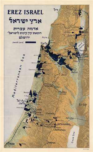
EREZ ISRAEL ארץ ישראל
sold
- Digital Map Information
- Suitable for large format printing
- File Size: 31.86 MB
- File Type: ZIP / TIFF
- ICC color profile embedded
- Delivered instantly via download link
This c. 1925 Jewish National Fund Zionist map of Jewish land in Palestine highlights the Jewish National Fund's (JNF) push to acquire land in Palestine for Jewish settlement. Areas shaded black indicate land owned by the JNF where it established Jewish settlements. Although unclear from reading the map, the JNF likely founded many of the smaller settlements identified. Major cities outside the areas are identified, including Jerusalem, Bethlehem, Tel Aviv, Jaffa, and Haifa. The JNF, founded as part of the early 20th-century Zionist movement, played a critical role in establishing Tel Aviv. Major highways (and possibly railroads) are illustrated as well. (more details)
Zionism! Jewish-owned land in British Palestine. Proof state.
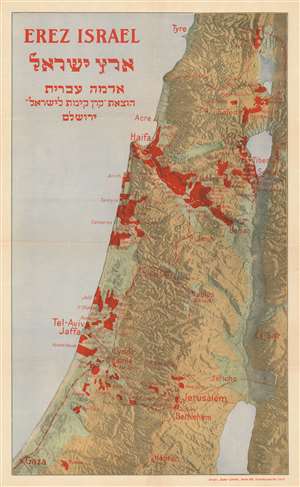
EREZ ISRAEL ארץ ישראל
sold
- Digital Map Information
- Suitable for large format printing
- File Size: 33.51 MB
- File Type: ZIP / TIFF
- ICC color profile embedded
- Delivered instantly via download link
This is the proof state of the c. 1925 Jewish National Fund Zionist map of Jewish land in Palestine highlights the Jewish National Fund's (JNF) push to acquire land in Palestine for Jewish settlement. Areas shaded red indicate land owned by the JNF where it established Jewish settlements. Although unclear from reading the map, the JNF likely founded many of the smaller settlements identified. Major cities outside the areas are identified, including Jerusalem, Bethlehem, Tel Aviv, Jaffa, and Haifa. The JNF, founded as part of the early 20th-century Zionist movement, played a critical role in establishing Tel Aviv. Major highways (and possibly railroads) are illustrated as well. (more details)
זאת הארץ אשר נפל לכם בנחלה… (במדבר ל''ג, ב')
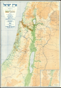
[Land of Israel.] / .ארץ ישראל
sold
- Digital Map Information
- Suitable for large format printing
- File Size: 40.17 MB
- File Type: ZIP / TIFF
- ICC color profile embedded
- Delivered instantly via download link
This is a 1934 Jewish National Fund Zionist map of Israel highlighting the Jewish National Fund's (JNF) push to acquire land in British Mandate Palestine for Jewish settlement. The map propagandizes the JNF's Zionist agenda and celebrates their significant successes. The JNF, founded as part of the early 20th-century Zionist movement, played a critical role in establishing a Jewish presence in Palestine in the decades before the creation of the Israeli state. (more details)
Celebrating the JNF.
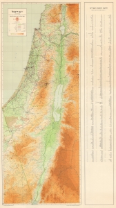
ישראלמפת היסוד של הקרן הקיימת לישראל / [Israel. Base Map of the Jewish National Fund for Israel]
sold
- Digital Map Information
- Suitable for large format printing
- File Size: 41.79 MB
- File Type: ZIP / TIFF
- ICC color profile embedded
- Delivered instantly via download link
This is a 1950 Jewish National Fund Zionist map of Israel highlighting the Jewish National Fund's (JNF) successful efforts to settle Israel. It was published one year after the 1949 Armistice Agreements ending the 1948 Arab-Israeli War and thus reflects the 'Green Line' thus established, which separated Arab-controlled territory (i.e., the Jordanian-annexed West Bank and the Egyptian-occupied Gaza Strip) from Israel until the latter's victory in the 1967 Arab-Israeli War. The map propagandizes the JNF's Zionist agenda and celebrates its significant successes. The JNF, founded as part of the early 20th-century Zionist movement, played a critical role in establishing a Jewish presence in Palestine in the decades before the creation of the Israeli state. (more details)
Kibbutz Movement in Israel. 'A Wonderful Community...'
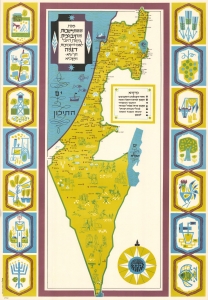
מפת ההתישבות הקיבוצית בשנת היובל לאם הקבוצות, דגניה, תzא-תשכא. / Map of the Kibbutz Settlements at the Jubilee of the Mother of Kibbutzim, Degania 1910-1961.
sold
This is a 1961 Shmuel Katz pictorial map of Israel celebrating the 50th anniversary, or 'Jubilee', of Degania Alef, the first Kibbutz founded in modern-day Israel. (more details)
Recruiting Zionist Youth to Settle Galilee.
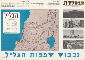
A scarce, remarkable work of persuasive cartography, this 1965 map with accompanying text and photographs was published by the Jewish National Fund (JNF). It advocates Zionist settlement in the Galilee region, a frontline in the frozen Arab-Israeli conflict that would again see large-scale fighting soon afterward in the Six-Day War. (more details)