
King, Chris (sold)

Chris King (fl. 1980 - present) began publishing the Jackson Hole Picture Map in 1980 from his commercial art studio in Aspen, Colorado. He bought the Aspen Picture Map in 1982 (the map was first issued in 1974) and completely overhauled the publication. The maps are updated annually and are published by King Picture Maps, Inc.
Scarce pictorial map of Jackson Hole.
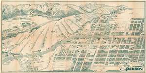
This is a 1983 Chris King pictorial map of Jackson Hole, Wyoming. The town of Jackson, Wyoming, occupies most of the foreground, with hotels, restaurants, shops, and more illustrated in profile. 'Signs' label businesses that occupy the same building, such as the Trading Post Mall and Cache Creek Square. Other locations are numerically marked and correspond with verso-content. The Rocky Mountains occupy the background, with Teton Village, Spring Creek Ranch, and Wagon Wheel Village are illustrated. (more details)
A moment in Aspen.
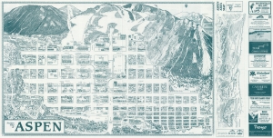
This is a 1989 Chris King's Picture Map of Aspen, Colorado. King's Map, published in numerous editions over many years, chronicles Aspen's business and social life, with each edition offering a novel record of Aspen's development. (more details)