
Kaiserlich-Königliches Militär-Geographisches Institut (sold)

Kaiserlich-Königliches Militär-Geographisches Institut (Imperial Royal Military Geographical institute. (active 1839 - 1921) was a military institution of the Austrian Empire, responsible for producing maps for the military; the Institut was in charge of the whole process, from initial survey to reproduction and publication. It had its roots in the military topographical corps of the Cisalpine Republic, established in Milan in 1800. The corps was absorbed by the formation of the Austrian Kingdom of Lombardy-Venetia in 1814, and continued operations: gradually, the organization was transferred to Vienna, a process completed in 1839. Its directors would govern a large (and sadly anonymous) corps of geographers and engineers, producing maps of grand size and granular detail. The Institut won international renown, receiving the Grand Medal at the London Great Industrial Exhibition in 1851 for outstanding achievements in the field of military maps. This excellence was not only in surveying, but also in map printing; the Institut applied and refined technological developments in lithography, copperplate engraving, and electroplating in the reproduction of maps. While the Institut was primarily focused on the production of maps for the military, maps approved for distribution were sold via the Vienna art dealer Artaria.
Specially-assembled folding map of Bosnia-Herzegovina.
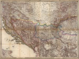
Bosnia, Herzegovina etc. (title on slipcase)
sold
- Digital Map Information
- Suitable for large format printing
- File Size: 122.3 MB
- File Type: ZIP / TIFF
- ICC color profile embedded
- Delivered instantly via download link
This elegant and detailed Austrian map of Bosnia and Herzegovina, likely a unique production, was mounted and sold by Artaria, c. 1878. It is a compilation of sheets II, III, V and VI from Joseph von Scheda's General-Karte der Europaeischen Turkei und des Konigreiches Griechenland; of the 13 sheets of this mammoth map, these were the four that centered on Bosnia and Herzegovina - which had been awarded to Austria - Hungary by the terms of the Treaty of Berlin in 1878. Hence, the immediate relevance of the map as presented here. (more details)
Mapping the Balkans in Revolt. Likely the best map of the region to appear in the 19th century.
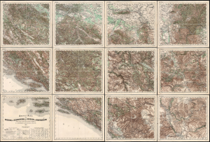
General Karte von Bosnien, der Hercegovina, von Serbien und Montenegro...
sold
- Digital Map Information
- Suitable for large format printing
- File Size: 467.78 MB
- File Type: ZIP / TIFF
- ICC color profile embedded
- Delivered instantly via download link
This monumental, scarce, 12-sheet map of the Balkans was produced by Austria-Hungary's Imperial-Royal Military Geographical Institute. Published in early to mid-1876, this meticulously detailed military map captures the Balkans during the Great Eastern Crisis (1875 - 1878), which culminated in the Monarchy's absorption of Bosnia and Herzegovina pursuant to the 1878 Treaty of Berlin. When issued, it was the most detailed published general map of this geographically and politically multifaceted region. (more details)