
Labouche Frères (sold)

An rare city map of Toulouse, France, a city which dates back to Roman times.
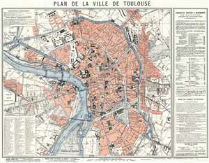
Plan de la Ville de Toulouse.
sold
- Digital Map Information
- Suitable for large format printing
- File Size: 35.79 MB
- File Type: ZIP / TIFF
- ICC color profile embedded
- Delivered instantly via download link
This is a 1921 Labouche Frères city map or plan of Toulouse, France. The map depicts the city from the Gare de Toulouse to the Cimetière de Terre Cabade and from the Gare Raynal to the Parc du Ramier du Chateau, which is most likely where the Stade TFC is situated today. Myriad buildings are labeled throughout, such as train stations, churches, government buildings, and schools. Roads, town squares, and parks are also identified. Town districts are noted. An index of major buildings throughout the city, including churches, military posts, City Hall, the town markets, and historic buildings, is situated along the right border, while a street index is included in the lower left corner. Both maps give the location of each site relative to its location on the map's grid, since the entire map is divided up into a grid and each square is assigned a number. That way the viewer can locate anywhere that they want to go. (more details)