
Lafreri, Antonio (sold)

Antonio Lafreri (1512–1577), born Antoine du Pérac Lafréry, was a Burgundian engraver, cartographer and publisher active in Rome in the 16th century. Apart from his birth in Orgelet in Burgundy, nothing is known about his early life, education or training. He is thought to have arrived in Rome by 1540 and was established as an engraver and printmaker in 1544. He became a business partner with Antonio Salamanca the Elder in 1553, until his partner's death in 1562. He would continue in the trade as a successful publisher of maps in the 1560s, and by 1570 he was selling made-to-order atlases both of his own maps and those of his collaborators. By the time of his death he was the leading dealer of engravings in Rome. His work was instrumental in disseminating the geographical ideas of Giacomo Gastaldi, but his battle scenes and maps focusing on the wars between Venice and the Ottoman Empire (particularly the famous Siege of Malta) are particularly prized. He is also noted for his Speculum Romanae Magnificentiae, a three volume collection of engravings of Rome produced over the course of the latter part of Lafreri's career, from 1545 to 1577. Other mapmakers in Rome and Venice sharing both Lafreri's aesthetic and geographical sources such as other Battista Agnese, Antonio Salamanca, Francesco Camocio the Younger, Donato Bertelli, Ferando Bertelli and Paolo Forlani are collectively generally referred to as belonging to the 'Lafreri' school of mapmakers, although this was not a formal organization. The terms 'Lafreri Atlases' and 'IATO (Italian, Assembled To Order) Atlases' are used to refer to the same class of works. He died at Rome in 1577.
Contemporaneous Depiction of the Most Celebrated Battle in 16th Century Europe.
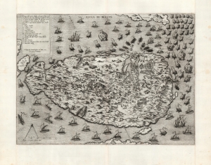
Disegno dell Isola di Malta con li porti et forti… In Roma per Antonio Lafreri nel anno 1565…
sold
- Digital Map Information
- Suitable for large format printing
- Full resolution TIFF file
- ICC color profile embedded
- Delivered instantly via download link
This is an extremely rare and striking 1565 'first state' Antonio Lafreri map of the island of Malta, during the momentous Great Siege of Malta in 1565, printed just a month into the four-month-long battle. At the time, Malta was the last major redoubt of the Knights Hospitaller, a militant monastic order of the Catholic faith that can trace its origins to the Crusades. The siege was thus framed in Europe as an epic good-vs-evil struggle between European Christianity and the Islamic Ottoman Empire. The ultimate defeat of the Ottoman forces became one of the most celebrated events not only of the 16th century, but for centuries to come: in the 18th century, the French writer, historian and philosopher Voltaire write, 'Nothing is better known than the siege of Malta.' (more details)
A superb, untrimmed example.
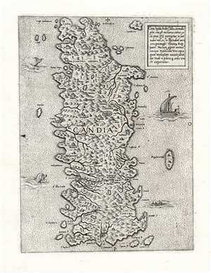
Creta Insula, hodie Cādia, in medio pōto sita est.
sold
- Digital Map Information
- Suitable for large format printing
- Full resolution TIFF file
- ICC color profile embedded
- Delivered instantly via download link
This is an immaculate example of a rare map of the Island of Crete, attributed to Antonio Lafreri. The east-oriented map illustrates the island's topography based on the late model exhibited first in the 1513 Waldseemuller map, and introduced to Venice via Matteo Pagano's 1538 map. (more details)