
Langren, Hendrick Florent van (sold)

Hendrick Florent van Langren (1574 - 1648) was a member of the van Langren dynasty of Dutch engravers, map publishers, and globe makers. Initially settled in Antwerp, the family moved to Amsterdam and would be instrumental in the early map trade. Hendrick and the elder Langren, Jacob, engraved many of the maps of Jan van Linschoten's Itinerario, thus creating the images attending one of the most influential travel works published.
The Heart of Portuguese Power in the East.
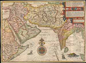
Deliniantur in hac tabula, Orae maritimae Abexiae, freti Mecani. al. Marís Rubri, Arabiae, Ormi, Persiae...
sold
- Digital Map Information
- Suitable for large format printing
- DPI: 600
- File Size: 59.14 MB
- File Type: ZIP / TIFF
- ICC color profile embedded
- Delivered instantly via download link
This is Jan van Linschoten's seminal 1596 map of the lands abutting the Indian Ocean, with coverage extending from the Arabian Peninsula to Sumatra. This map represents a significant advancement in accuracy and detail over any prior printed map of the region, setting the standard for most subsequent maps of the near east and south Asia for the remainder of the 16th and throughout the 17th century. Moreover, it exposed preciously guarded secrets of Portuguese maritime geography, paving the way for the Dutch seizure of the East India trade, thus spurring the Dutch Golden Age. (more details)
Earliest View of a strategic waypoint on maritime routes to the Far East.
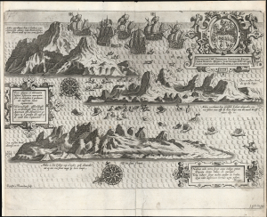
Vera effigies et delineatio insulae. Ascenscio nuncupatae... Waerachtighe affbeeldinghe en verthooninghe vant eylant Asçençion...
sold
- Digital Map Information
- Suitable for large format printing
- Full resolution TIFF file
- ICC color profile embedded
- Delivered instantly via download link
This is Jan van Linschoten's 1596 view of Ascension Island - considered the earliest printed depiction of Ascension Island in the South Atlantic. This view derives from Linschoten's firsthand observation: his narrative of his return to Europe from India describes the approach to the island, sailing northwest from the Cape of Good Hope, the abundance of the island's fish (including flying fish smacking into the ships), and the fleet's continued journey to Cape Verde and the Canaries. (more details)