
Lee, Edmund Francis (sold)

Edmund Francis Lee (1809 - July 18, 1857) was an American surveyor and civil engineer active in the early to mid-19th century. Lee is most famous for the 'Lee Map', the first survey of Mammoth Cave. Lee was born in Berlin, Connecticut and studied civil engineering at the American Literary, Scientific, and Military (A. L. S. M.) Academy. He relocated to Cincinnati, Ohio around 1835, where he drafted one of the first maps of Texas for Joseph A. James (1807 - 1882). Shortly thereafter he was contracted to chart the first 8 miles of Mammoth Cave. The subsequent map became the definitive map of Mammoth Cave until it was resurveyed in the 1880s. Subsequently in mid-1836, Lee relocated to Jeffersonville, Indiana where he taught geography, mathematics, drafting, surveying, and civil engineering in the newly formed Literary and Scientific Academy. He was apparently poorly suited to teaching, and resumed civil engineering, re-platting Jeffersonville and other towns in Kentucky in Indiana. In 1846 he was elected county surveyor of Louisville, Kentucky. In this position he completed, in 1850, a detailed topographical survey of Kentucky became the definitive map of the state throughout the Civil War (1861 - 1865). He also designed several cemeteries, including Cave Hill Cemetery, Louisville.
On the eve of the Texan Revolution...
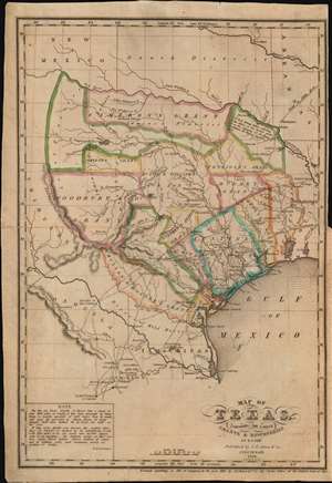
Map of Texas, containing the latest Grants and Discoveries by E. F. Lee.
sold
- Digital Map Information
- Suitable for large format printing
- Full resolution TIFF file
- ICC color profile embedded
- Delivered instantly via download link
The rare 1836 Edmund F. Lee map of Texas and accompanying History of Texas by David Barnett Edward - a seminal work published on the eve of the March 1836 Texan Revolution and founding of the Republic of Texas. The map is loosely derived from the Stephen Austin map, the only readily available source at the time, but has been reduced and revised by Lee for smaller format publication. It unveils Texas extending from the Sabine to the Nueces River and from Corpus Christi to the Red River. A note in the lower left expresses the Texan ambition to extend the boundary west as far as the Rio Grande. The map notes several early Texas Empresario Land Grants, including: 'McMullen and McGlone', Woodbury, Cameron (2), 'Austin and Williams', Austin, DeWitt, Austin's Colony, De Leon, Burnet, Powers, Whelin, Zavallo, and Felisola. (more details)