
Long Island Canal Company (sold)

The Long Island Canal Company - proposed in 1824, incorporated in 1828 - was established with the purpose of linking the bays of southern Long Island with navigable passages, from Gravesend Bay to Fire Island Inlet (or more ambitiously, to Shinnecock Bay.) There is no evidence of the company having met any of its goals and it is unclear when the company disbanded; indeed a ‘Long Island Canal and Navigation Company’ was formed in 1848 with similar purpose, also folding without having achieved its aims.
Rare American Map of Long Island Promoting the Long Island Canal Company.
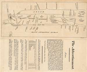
The Advertisement. Notice is hereby given, that Application will be made to the Legislature next Session, for an Act of Incorporation for the Long-Island Canal Company…
sold
- Digital Map Information
- Suitable for large format printing
- DPI: 600
- File Size: 3.86 MB
- File Type: ZIP / TIFF
- ICC color profile embedded
- Delivered instantly via download link
This is an 1824 map of Long Island, the earliest separate map we have identified of Long Island printed in the United States. The map was drawn with accompanying text to promote the construction of a new canal in southern Long Island - an effort that would presumable have significantly increased trade communication between southeastern Long Island and New York City, and from there, the world. It shows the cities of New York and Brooklyn pictorially; the Long Island towns of Flushing, Jamaica, Hampsted, Oyster Bay, Smithtown Brookhaven, Riverhead, Southold, Oysterponds, Southhampton, and Easthampton are marked on the map. In Connecticut, Rye, Stamford, Norwalk, Fairfield, New Haven and New London are named. The map is schematic in the extreme, with its best detail shown along the southern shore of the island - detailing the inlets along the barrier islands from Coney Island, Rockaway and Fire Island, and the waterways just inland. (more details)