
Loss, Charles F. (sold)

Charles F. Loss (1765 - 1822) was a New York City surveyor active in the late 18th and early 19th century. In 1804, Loss laid out the street grid for Hoboken, presaging the more famous 1811 Commissioners Plan of New York City. He was appointed City Surveyor in 1811. In this role he was assigned to review the work of Joseph-Francois Mangin (1758 - 1818), which would ultimately result in the Mangin-Goerck Plan of New York. Loss was no friend to Mangin, who was a prodigy of Alexander Hamilton, and, in fact, was closely tied to the profiteering political machinations of Hamilton's nemesis Aaron Burr (1756 - 1836). Loss derided Mangin's work and led to the 1803 Mangin-Goerck plan to being rejected.
First specific map of Tribeca?
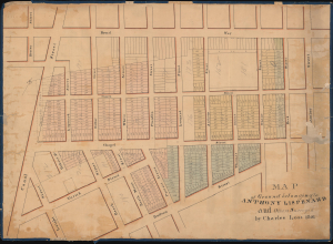
Map of Ground belonging to Anthony Lispenard and Others Surveyed by Charles Loss 1801.
sold
- Digital Map Information
- Suitable for large format printing
- DPI: 600
- File Size: 756.49 MB
- File Type: ZIP / TIFF
- ICC color profile embedded
- Delivered instantly via download link
This unique c. 1803 manuscript is likely the earliest surviving specific map to detail modern-day Tribeca, New York City. The map is oriented to the east, with coverage extending from Canal Street to Chambers Street and from Broadway to Hudson Street. These were lands owned by Anthony Lispenard Bleecker (1741 - 1816). (more details)