
Lufkin, Richard Friend (sold)

Richard Friend Lufkin (1895-1963) was a professional civil engineer and head of the Richard Lufkin Company (engineers, draftsmen, artists, and cartographers). He was an Abraham Lincoln scholar and published a number of writings and illustrated maps revolving around Lincoln and his time spent in New England. His company produced a number of pictorial maps focused on Massachusetts, as well as for a number of years printing the map of Boston's MTA.
Highlights Boston's mass transit network, including the elevated railway and the subway, the first built in the United States.
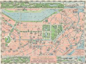
The Central Part of Boston, Massachusetts, showing transportation lines of the Boston Elevated Railway.
sold
- Digital Map Information
- Suitable for large format printing
- File Size: 41.08 MB
- File Type: ZIP / TIFF
- ICC color profile embedded
- Delivered instantly via download link
This is a 1930 Richard F. Lufkin pictorial city plan or map of Boston, Massachusetts. Focused on the central part of the city, blue lines trace Boston's elevated railway ('El'), subway, bus, and trolley lines. The solid blue lines, long-dashed lines, and short-dashed lines all mark different types of rapid transit. Unfortunately, between the key in the lower-left corner and the map itself, it is unclear exactly which type of mass transit is represented. It appears that the solid line and the long-dashed line mark the subway, elevated railway, and the trolley lines interchangeably. The only truly clear annotation concerns the bus lines, which are traced by the short-dashed lines. Stations are labeled, including the Park Street Stations on Lafayette Mall, which are illustrated in profile. Boston's many landmarks are depicted in profile, including Fenway Park, Trinity Church, the State House, Massachusetts General Hospital, and the Massachusetts Institute of Technology across the Charles River in Cambridge. Boston Common and the Public Garden appear as a green island in the middle of the city. Small bird's-eye views act as the top and bottom borders. They include views of Harvard University's campus, Middlesex Fells Reservation, the U.S. Navy Yard, the municipal airport, and South Boston, with numerous buildings illustrated in profile in each place. (more details)