
Lythe, Robert (sold)

Robert Lythe (fl. 1556-1571) was an English surveyor and mapmaker. Nothing is known of his early life. Although he appears to have specialized as a military surveyor, he was sufficiently broadly educated to be able to make references to hydrography, land quality, natural curiosities and local history in his manuscript maps - which were themselves neatly and attractively executed. His earliest known work was a map of the vicinity of Calais produced during an Anglo-French border dispute. His farthest-reaching work were the Irish surveys he executed between 1567 and 1570, on behalf of the British government, in order to better understand how best to garrison and colonize Ireland following the Tudor conquest. Though these surveys were not for many years broadly disseminated, they would inform to a greater or lesser extent the maps executed by Mercator, Plancius, Boazio and Norden. Jodocus Hondius drew on Lythe for the Ireland maps he produced for van der Keere and Speed: thereafter, Speed’s 1610 map of Ireland incorporating Lythe’s surveys would provide the basis for most 17th century maps of the island.
An Abundantly Detailed Tudor Map of Ireland
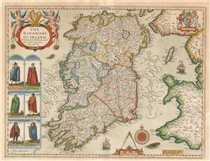
The Kingdome of Irland Devided into Severall Provinces, and thē againe devided into Counties. Newly described.
sold
- Digital Map Information
- Suitable for large format printing
- DPI: 600
- File Size: 19.63 MB
- File Type: ZIP / TIFF
- ICC color profile embedded
- Delivered instantly via download link
This is John Speed's map of Ireland, the first map of Ireland published in an English atlas. Engraved in 1610, It was included in Speed's The Theatre of the Empire of Great Britaine, which was the first collection of maps of the counties of the British Isles. The engraving is the work of Jodocus Hondius, who engraved many of the plates of Speed's atlases. This was fortunate for Speed. Hondius had become familiar with the Irish surveys of Robert Lythe. Lythe, an English surveyor and topographer, had been tasked by the British government between 1567 and 1570 to survey Ireland in the wake of the Tudor Conquest, in order to aid the garrisoning and colonization of the island. Lythe's survey proved a mammoth undertaking. Of it, J. H. Andrews remarked:
Since the number of Lythe’s Irish place-names runs to several thousands (no other Elizabethan surveyor reached four figures) his visit must—on grounds of quantity alone—be accounted the most important event in the cartographic history of sixteenth-century Ireland.Despite these being the most up-to-date surveys of Ireland, they were not well disseminated until the end of the 17th century. Ortelius' maps, for example, were based on Mercator's outdated mapping of the 1560s, and did not benefit from Lythe's contemporaneous surveys. Hondius, on the other hand, had encountered Lythe's work while living in England, and he drew on it while executing Pieter van den Keere's 1592 Hyberniae novissima descriptio as well as the map he engraved for Speed. (The sole known copy of the Kaerius map survives in Linen Hall, Belfast.) (more details)