
Machoni, Antonio (sold)

Antonio Machoni (1671 - 1753) was a Sardinian Jesuit missionary and scholar. Upon ordination in 1698, he was sent to the Missions of Paraguay. He participated in Esteban de Urízar's 1708 exploration of the Chaco, west of the Paraguay River. Thereafter, he lived and worked in the Gran Chaco region. During this period, he produced a grammar of the Lulé people of the Chaco, whose mission Machoni was in charge of. In 1728, he was sent back to Spain and Rome to serve as representative there for the Paraguayan missions. While in Europe, he published (in 1732) his Lulé grammar; it is probably during this period that he applied corrections to D'Avila's cartography of the Chaco region, which would remain in that foundational work in its 1732 and later editions. In 1733, he returned to South America, eventually becoming Provincial of the Jesuit Province of Paraguay, a position he would hold until 1743.
Scarce Map of La Plata.
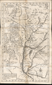
Descripción de las Provincias del Chaco, y confinantes segun las relaciones modernas, y noticias aquiridas por diversas entradas de los Missioneros de la Companía de Iesus que se han hecho en este siglo de 1700.
sold
- Digital Map Information
- Suitable for large format printing
- File Size: 14.5 MB
- File Type: ZIP / TIFF
- ICC color profile embedded
- Delivered instantly via download link
This rare 1733 Pedro Lozano map of central South America, engraved by Giovanni Petroschi, is the first appearance of Antonio Machoni's amendments to Juan Francisco D’Avila's foundational map of the La Plata region. These changes were made both to the Chaco region on the west bank of the Paraguay River (the location of Machoni's missionary work) and the southern coast of what would become Uruguay. The region was a key theatre of Jesuit missionary activity; consequently, the Jesuits produced the first accurate maps of the complex river systems emptying into the Rio de la Plata. The present work illustrates the process of revision over the 18th century, with the contributions of key cartographers and missionaries. (more details)