
Major, Henry Brougham (sold)

Henry Broughman Major (February 17, 1820 - August 28, 1887) was an American lithographer based in New York in the middle to late 19th century. Major was born in Frome, England and emigrated to the United States in 1834. He apprenticed under Nathaniel Currier (1813 - 1888), befriending Currier lithographer Napoleon Sarony (1821 - 1896). Major worked briefly on his own, or perhaps with his cousin James Parsons Major, from 1845 - 1846 at 10 Watts Street. In 1846 he joined Sarony to found 'Sarony and Major', based at 117 Fulton Street, New York. Henry Major left the firm in 1853 for unknown reasons. At this time, a relative, possibly his son, Richard C. Major, continued to work with Sarony and Joseph Fairchild Knapp (1832 - 1891), creating the firm 'Sarony, Major and Knapp' (1857 - 1863).
Union Square Park shortly after opening.
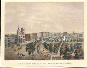
View of Union Park, New York, from the Head of Broadway.
sold
- Digital Map Information
- Suitable for large format printing
- DPI: 600
- File Size: 17.54 MB
- File Type: ZIP / TIFF
- ICC color profile embedded
- Delivered instantly via download link
This is an 1849 James Smillie view of Union Square and Union Square Park - published roughly 6 years after it opened. Union Square Park dominates the right side of the view, with the park's beautiful fountain and tree-lined pathways. Well-dressed New Yorkers stroll along these pathways. The Stringer Institute, the Church of the Puritans, and Abbott's Collegiate Institution for Young Ladies appear in the foreground. Cavalry Church and the Free Academy are illustrated in the distance. (more details)
The 'upside down map' of Elizabethtown.
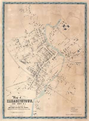
Map of Elizabethtown, Essex County N.J.
sold
- Digital Map Information
- Suitable for large format printing
- DPI: 600
- File Size: 130.17 MB
- File Type: ZIP / TIFF
- ICC color profile embedded
- Delivered instantly via download link
This is a c. 1851 John Bevan wall city plan or map of Elizabethtown, Essex County, New Jersey. Sometimes called the 'upside down map' because it is oriented with south at the top, Bevan's map captures a moment in Elizabethtown's history, identifying many of its residents and buildings. Churches, schools, the post office, and the town's two hotels are labeled. Dry goods stores, groceries, the fish market, and a boot store are marked as well. Carpenters, tailors, butchers, bakers, and cabinet makers are identified by name. More specialty shops, such as a watch maker, the coach factory, and the oil cloth carpet factory enhance the understanding of life in Elizabethtown at this point in time. (more details)
Profiles in Central Park along hypothetical extensions of Sixth and Seventh Avenue.
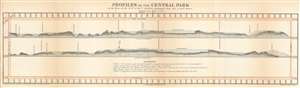
Profiles of the Central Park on the lines of the VIth and VIIt Avenues prolonged from 59th to 110th Street.
sold
- Digital Map Information
- Suitable for large format printing
- File Size: 5.56 MB
- File Type: ZIP / TIFF
- ICC color profile embedded
- Delivered instantly via download link
This 1860 Frederick Law Olmsted and Calvert Vaux profile chart or map of Central Park in New York City provides a glimpse into the wide-ranging topography of one of the world's greatest urban parks. Olmsted and Vaux employ Manhattan's iconic grid system and illustrate the topographic profiles along hypothetical extensions of Sixth and Seventh Avenues. Landmarks within the park, including the transverse roads, the carriage road, the New Reservoir, and The Bluff, are identified. Trees appear along some of the ridges, and higher ground to the west of the defined profiles appear as shadowy masses above the profiles. Manhattan's street grid borders the park on all four sides. (more details)