
Major, Richard C. (sold)

Richard C. Major (18?? - May 18, 1894) was a New York City and Brooklyn based American lithographer active in the second half of the 19th century. He likely apprenticed under his father Henry B. Major and Napoleon Sarony (1821 - 1896). In 1857, he became a partner in the firm of 'Sarony, Major and Knapp' (1857 - 1863), which from 1863 to 1888 operated as 'Major and Knapp.' In 1888, Richard retired, but in 1891 ran for 'Lithography Commissioner' at the 1891 Buffalo Pan-American Exposition. The 'Major and Knapp' firm was renamed Knapp and Company and operated under Joseph Fairchild Knapp (1832 - 1891) and his son, Joseph Palmer Knapp (1864 - 1951) from 56 Park Place, New York, until 1892. Like his partner, Major was also a major investor and director of the Metropolitan Life Insurance Company. When he died he left a fortune of 280,000 USD, about 10,000,000 USD in modern-day terms.
A rare view of a Union Army encampment in North Carolina.
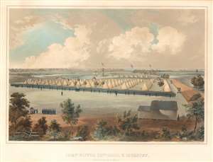
Camp Oliver 25th Mass. V. Inf., New Berne, N.C. 1862-3.
sold
- Digital Map Information
- Suitable for large format printing
- File Size: 13.86 MB
- File Type: ZIP / TIFF
- ICC color profile embedded
- Delivered instantly via download link
This is an extremely rare 1863 Voltaire Combe view of Camp Oliver, North Carolina during the American Civil War. The view depicts the camp when it was occupied by the 25th Massachusetts Volunteer Infantry during its 1862-1863 campaign in North Carolina. Per Joseph Waldo Denny, a veteran of the 25th Massachusetts, Camp Oliver 'was one of the best located and most conveniently arranged places ever occupied by the regiment. It furnished an extensive parade ground and ample room to allow company streets of more than 'Regulation' width, and a camp frontage of almost double the prescribed paces.' Denny also described life in the camp, stating that 'While at Camp Oliver, the regiment was drilled daily, the forenoons being occupied with company, and the afternoons with battalion drill.' Unfortunately, little else is mentioned. (more details)
Gold and silver.
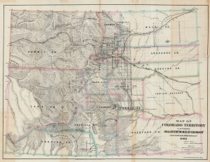
Map of the Colorado Territory to accompany Hollister's 'Mines of Colorado' corrected from the Public Surveys of 1866.
sold
- Digital Map Information
- Suitable for large format printing
- File Size: 51.64 MB
- File Type: ZIP / TIFF
- ICC color profile embedded
- Delivered instantly via download link
This is an 1867 Major and Knapp map of the Colorado Territory. Gold, silver, and coal deposits are marked throughout with the 'developed gold region' identified. The territorial capital was then at Golden City. (more details)