
McLean, Thomas Wesley (sold)

Thomas Wesley McLean (1881 - 1951) was a Canadian artist and graphic designer active during the early- to mid-twentieth century.
A charming pictorial map featuring all five Great Lakes.
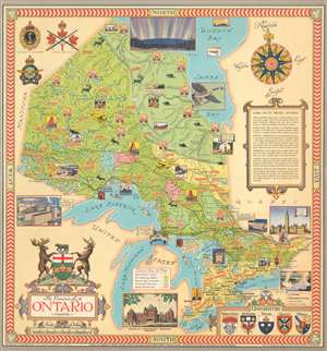
The Province of Ontario, Canada.
sold
- Digital Map Information
- Suitable for large format printing
- File Size: 33.53 MB
- File Type: ZIP / TIFF
- ICC color profile embedded
- Delivered instantly via download link
This is a 1950 Thomas Wesley McLean and Alexander Scott Carter pictorial map of the five Great Lakes and the province of Ontario, Canada. The map depicts the region from Manitoba to Quebec and from the Hudson Bay to Lake Erie. Each of the five Great Lakes, situated in the bottom half of the map, are labeled. Ships are illustrated plying their waters and fish hint at the natural bounty provided by the lakes themselves. Manitoulin Island, the largest freshwater island in the world, is illustrated and labeled. Vignettes present charming scenes of life in Ontario, such as a musher with a team of sled dogs, a woodsman transporting logs via horse-drawn sledge, and people in a canoe on one of the province's many rivers and lakes. Other vignettes highlight Ontario's industry, such as power stations, grain elevators, iron mines, and individual industries, including lumbering, fur, pulp and paper, farming, and the mining of iron and gold are referenced by colorful banners. Illustrations of animals native to Ontario, including polar bears, caribou, moose, and beaver, dot the landscape.
Toronto, Sault St. Marie, Kingston, and Ottawa are among the numerous cities, towns, and villages labeled throughout the province. Railroads connect many of these cities, although no roads are shown. A key situated in the bottom third of the map explains the different colors used and how they provide information concerning land use. A decorative title cartouche is situated in the lower left corner, with a view of the Provincial Parliament Building in Toronto to its right. In the lower right corner sits an inset that displays the coats of arms of five universities based in Ontario, including Ottawa, Toronto, and Queen's. An illustration of the Dominion Parliament Building in Ottawa, placed along the right border, appears below a cartouche bearing facts about the province of Ontario. Badges of the Canadian Army, Navy and Air Force are included in the upper right corner. (more details)
Toronto, Sault St. Marie, Kingston, and Ottawa are among the numerous cities, towns, and villages labeled throughout the province. Railroads connect many of these cities, although no roads are shown. A key situated in the bottom third of the map explains the different colors used and how they provide information concerning land use. A decorative title cartouche is situated in the lower left corner, with a view of the Provincial Parliament Building in Toronto to its right. In the lower right corner sits an inset that displays the coats of arms of five universities based in Ontario, including Ottawa, Toronto, and Queen's. An illustration of the Dominion Parliament Building in Ottawa, placed along the right border, appears below a cartouche bearing facts about the province of Ontario. Badges of the Canadian Army, Navy and Air Force are included in the upper right corner. (more details)