
Mehmet Nasrullah (sold) (محمد نصرالله)

Mehmet Nasrullah (محمد نصرالله; fl. c. 1890 - 1910) was one of the most prominent geographers of the late Ottoman period. He is best known for his Atlaslı coğrafiya-yi Osmani and other atlases, but he also produced a series of wall maps with Tefeyyüz Kitaphanesi. In some biographies, he is noted as being a haji. He may be the same person as one al-Hac Nasir al-Dagistani, in which case he likely would have been a native of Dagestan in the Caucasus.
AKA: محمد نصرالله
Southeastern Europe, Slipping Away.
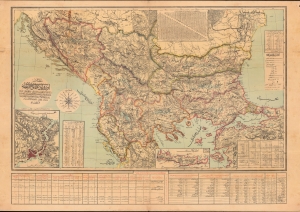
مفصل اوروبا عثمانیه / [Detailed (Map) of Ottoman Europe].
sold
- Digital Map Information
- Suitable for large format printing
- File Size: 1159.59 MB
- File Type: ZIP / TIFF
- ICC color profile embedded
- Delivered instantly via download link
A scarce map of Ottoman Europe, produced by military officer al-Hac Nasir al-Dagistani and published in 1906 by Mahmud Bey Matbaasi. It displays the remaining European portion of the Ottoman Empire, which was severely imperiled at the time, and most of which would break away in two wars in the Balkans that directly preceded World War I (1914 - 1918). (more details)
Ottoman Cartography.
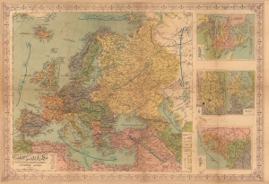
مكمل آوروپا خريطه سى / [Complete Map of Europe].
sold
- Digital Map Information
- Suitable for large format printing
- File Size: 118.12 MB
- File Type: ZIP / TIFF
- ICC color profile embedded
- Delivered instantly via download link
A scarce and engrossing large format c. 1908 Ottoman Turkish wall map of Europe, produced by geographer Mehmet Nasrullah and published by Tefeyyüz Kitaphanesi in Istanbul. It reflects improvements in both Ottoman cartography and print technology in the last years of the long-ruling dynasty. (more details)