
Meisel, Augustus (sold)

Augustus Meisel (December 12, 1824 - January 24, 1885) was a German-American lithographer active in Boston during the mid-19th century. Born in Baden, Germany, Meisel immigrated to the United States United States with his brother Berthold (December 10, 1831 - April 5, 1915). The pair arrived in New Orleans on December 5, 1848. They were 48ers, those middle-class Germans who emigrated to the United States to avoid persecution associated with participating in the failed 1848 Springtime of the Peoples Revolutions. Augustus became a naturalized American citizen on September 3, 1855, with Berthold receiving his citizenship a little over a month later. The brothers worked together as lithographers in Boston until Augustus's death. He died January 24, 1885, of pneumonia.
Expansion and urbanization.
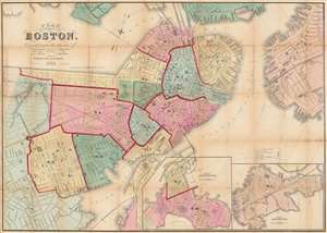
Plan of Boston Corrected under the direction of Charles W. Slack, Lewis Rice, Danl. J. Sweeney, Alderman, Com. Council, Committee on Printing, of 1867, by N. Henry Crafts, City Engineer.
sold
- Digital Map Information
- Suitable for large format printing
- Full resolution TIFF file
- ICC color profile embedded
- Delivered instantly via download link
An 1867 city map of Boston produced for the Boston City Engineer's Office. This map, updated regularly and based upon official engineering records, represents the finest mapping of Boston between 1860 and 1870 - Boston's most vibrant period of expansion, landfill development, urbanization, and modernization. (more details)
The official map of Boston following the Annexation of Roxbury.
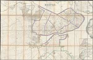
Plan of Boston.
sold
- Digital Map Information
- Suitable for large format printing
- File Size: 111.66 MB
- File Type: ZIP / TIFF
- ICC color profile embedded
- Delivered instantly via download link
The Boston City Engineer's Office produced this 1868 city plan or map of Boston. Depicting all the city of Boston, including the Roxbury, which was annexed into Boston January 5, 1868, shortly before this map went to press. Insets of South Boston and East Boston are situated on the bottom right. The color coding on the map refers to school districts with red indicating boy's schools, blue girl's schools, and green co-educational schools. As the most up to date official map of Boston, this map provided the base cartography for numerous subsequent commercial maps, including those issued by A. J. Johnson and Samuel Augustus Mitchell Jr. (more details)
Sportsman's Paradise.
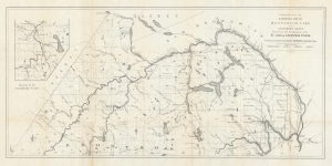
Supplement to Hubbards Map of Moosehead Lake and Northern Maine. Embracing the headwaters of the St. John and Aroostook Rivers.
sold
- Digital Map Information
- Suitable for large format printing
- File Size: 11.24 MB
- File Type: ZIP / TIFF
- ICC color profile embedded
- Delivered instantly via download link
An intriguing 1882 map of the northernmost portion of Maine, covering much of Aroostook County, prepared by Lucien Hubbard for Hubbard's Guide to Moosehead Lake and Northern Maine. Hubbard's maps and guides played an important role in popularizing inland Maine for travelers seeking a rustic retreat from coastal city living. (more details)