
Mercier, Jacques (sold)

Jacques Mercier (19xx - 19xx) was a cartographer most likely of French origin who created pictorial maps for magazines in the 1940s and 1950s. His work appeared in the magazines 7 Jours and Je Cherche in the 1940s and we have found a reference to at least one map that was published in Paris-Match in the 1950s. A few of his maps that are part of the collection at the Bibliothèque national de France appear to have been separately published by Editions Gutenberg in Lyon in 1945.
Predicting the Great Circle Routes.
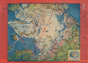
Routes de Guerre du Pôle.
sold
- Digital Map Information
- Suitable for large format printing
- Full resolution TIFF file
- ICC color profile embedded
- Delivered instantly via download link
This is a 1943 Jacques Mercier pictorial map of the North Pole, published in Lyon during World War II (1939 - 1945). The map posits a future where aviators could travel via the North Pole between Asia and North America. Though this is the shortest route between the continents, it was a technological impossibility at the time of publication. (more details)