
Mogg, Edward (sold)

Edward Mogg (fl. 1803 - 1860) was an English cartographer and engraver active in London during the first half of the 19th century. Unlike many cartographers of the period, Mogg personally engraved all of his own maps in a fine detail oriented hand. Mogg built his business on the production of guides, railway maps, and other publications focused on tourists and travelers in London. Mogg seems to have had a passion for defending tourist against the depredations of dishonest taxi cab drivers and was the first to introduced the innovative "Cab Fare Map and Guide". Mogg also published the 1822 edition of Paterson's Roads of England and Wales and a fascinating celestial sphere for school children.
Extraordinary first edition of Mogg's rare and important map of London, England.
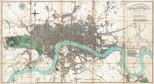
London in Miniature, with the Surrounding Villages Entire New Plan in which the Improvements both present and intended are actually reduced (by permission) from the surveys of the Several Proprietors.
sold
- Digital Map Information
- Suitable for large format printing
- DPI: 300
- File Size: 28.43 MB
- File Type: ZIP / TIFF
- ICC color profile embedded
- Delivered instantly via download link
An extraordinary first edition example of Edward Mogg's important 1806 case map of London, England. Covers the central part of London from Kensington to Greenwich and the East India Docks. Of this stunning map, Mogg writes ...like the clue of Ariadne, [it] will ... (more details)
Extremely rare case map of the area 24 miles around London, England.
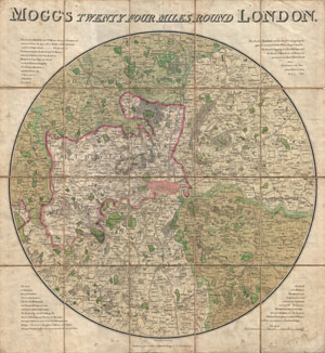
Mogg's Twenty Four Miles Round London.
sold
- Digital Map Information
- Suitable for large format printing
- DPI: 300
- File Size: 22.86 MB
- File Type: ZIP / TIFF
- ICC color profile embedded
- Delivered instantly via download link
Edward Mogg's extraordinary 1820 case map of the region 24 miles around London, England. Covers from Ryegate in the south to Hertfort in the north, and from Windsor in the west to Gravesend in the east. Mogg first issued this revolutionary circular format map ... (more details)