
Monteith, James (sold) (Master of the Margins)

James Monteith (April 3, 1831 - September 11, 1890) was a pioneering American cartographer, educator, and textbook author whose work shaped how geography was taught in the United States during the late 19th century. Born in Strabane, Ireland, Monteith immigrated to New York as a child and began teaching in the city's public schools by his late teens. A gifted artist and educator, he started publishing geography textbooks in the 1850s, initially collaborating with fellow teacher Francis McNally and publishing through A.S. Barnes and Company. Over a four-decade career, Monteith produced more than a hundred editions of geography texts, including First Lessons in Geography, Comprehensive Geography, and Barnes's Complete Geography. His maps were distinctive for their innovative use of color margins, which featured comparative data such as latitudes, areas, travel times, and terrain profiles, making complex geographic relationships accessible to students. Monteith's creative teaching methods included 'bird's-eye' relief views, map-drawing exercises, and inventive symbology that helped readers visualize the world in new ways. Though widely popular in his lifetime and foundational to American geography education, Monteith's contributions were later overshadowed as geography textbooks evolved, leaving him largely forgotten today despite his status as a 'master of the margins.'
AKA: Master of the Margins
Beautiful chromolithograph map of the world in hemispheres.
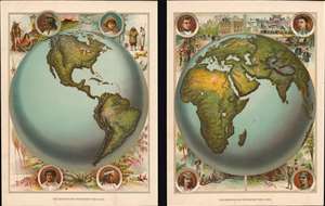
[Western Hemisphere]. [Eastern Hemisphere].
sold
- Digital Map Information
- Suitable for large format printing
- File Size: 13.6 MB
- File Type: ZIP / TIFF
- ICC color profile embedded
- Delivered instantly via download link
This is a c. 1885 James Monteith map of the world in hemispheres. Printed on two sheets, captions under both hemispheres state that they were 'photographed from a globe.' Each hemisphere appears on its own sheet and, and major mountain ranges, lakes, and rivers are visible. Ethnographic pictorial borders, complete with stereotypical views, adorn both sheets. Portraits of a North American Indian, and Esquimaux, a Sandwich Islander, and a South American Indian surround the Western Hemisphere, and purportedly depict these peoples in characteristic scenes. The North American Indian, sitting in front of their tepee, is accompanied by a sketch of an American bison. At the same time, a polar bear on sea ice overlooks the Esquimaux standing in front of their igloo. The portraits of the Sandwich Islander and the South American Indian focus on the tropical vegetation of their native lands. Portraits of a Caucasian, a Mongol, a Malay, and an Ethiopian surround the Eastern Hemisphere. A European thoroughfare accompanies the Caucasian, while the same sort of view of an Asian city acts as the backdrop for the Mongol. Landscapes, much like those on the Western Hemisphere sheet, are presented with the Malay and the Ethiopian and depict these people in purportedly natural settings. (more details)