
Mrak, Anton (sold)

Anton Mrak (1739 - 1801), also known as Antoni Mrakh, was a Slovenian mining engineer, surveyor, and cartographer active in the late 18th century. He was born in Idrija, Slovenia, the son and apprentice of the legendary Jožef Mrak (1709 - 1786), founder and the main representative of the so-called 'Idrija Cartographic School'. Works by Anton are few, but he did make a 1766 map of Istanbul / Constantinople and a 1784 geological map of Idrija's ore deposits.
Manuscript of the finest map of the Bosporus in the year of the Great Istanbul Earthquake.
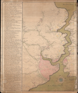
[Bosporus / Istanbul].
sold
- Digital Map Information
- Suitable for large format printing
- Full resolution TIFF file
- ICC color profile embedded
- Delivered instantly via download link
A unique 1766 manuscript map of Istanbul and the Bosporus drawn by the Slovenian surveyor and engineer Anton Mrak (1739 - 1801). This map represents the state-of-the-art mapping of the region in the year of the disastrous Great Istanbul Earthquake. The finely executed hand-drawn map is oriented loosely to the north, and covers the entirety of the Bosporus, the walled city of Istanbul, and the surrounding communities. Istanbul itself is mapped with great care, with coverage detailing the Sultanahmet, Eminoönü, Beyazit, and Fatih districts. Locations along the Bosporus are noted with detail. Curiously, the map is in Italian, but the alphanumeric key appearing along the left is in a combination of German and Ottoman Turkish. (more details)