
Nakamura Yoshimatsu (sold) (中村芳松)

Nakamura Yoshimatsu (中村芳松; fl. c. 1882 - 1906) was a major Japanese book and map publisher active in Osaka during the late 19th and early 20th centuries. The firm's output varied, but mostly consisted of maps, geographical texts, and works discussing or glorifying the military.
AKA: 中村芳松
Diplomatic ploy that may have contributed the Qing cession of Taiwan/Formosa to Japan.
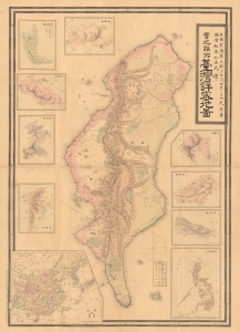
Detailed Map of Taiwan Field Survey. / 實地踏測台灣詳密地圖
sold
- Digital Map Information
- Suitable for large format printing
- File Size: 63.22 MB
- File Type: ZIP / TIFF
- ICC color profile embedded
- Delivered instantly via download link
This 1895 Nakamura Yoshimatsu map of Taiwan is one of the most unsung but influential examples of persuasive cartography ever published. The large-scale map of Taiwan appeared at the end of the First Sino-Japanese War (August 1, 1894 - April 17, 1895), just prior to the Treaty of Shimonoseki (April 17, 1895) and the Japanese invasion of Taiwan (May 29, 1895 - October 21, 1895). The map, attributed to a likely fictional British naval officer named John Waters, employs creative cartography to reshape Taiwan, while retaining the overall area, effectivley reducing the size of Qing controlled Formosa and increasing the size of the ungoverned 'savage zones' - a ploy that played into the Japanese position that the Qing did not truly possess the island. It was likely presented at the Shimonoseki negotiations, where the Japanese were able to take advantage of Qing China's infamous lack of cartographic knowledge about Formosa to formally seize the island. (more details)
Diplomatic ploy that may have contributed the Qing cession of Taiwan/Formosa to Japan.
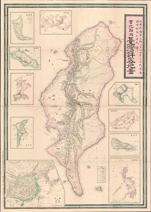
Detailed Map of Taiwan Field Survey. / 實地踏測台灣詳密地圖
sold
- Digital Map Information
- Suitable for large format printing
- Full resolution TIFF file
- ICC color profile embedded
- Delivered instantly via download link
The first Japanese printed map of Taiwan and the birth certificate of Japanese-occupied Formosa. An extremely scarce and important 1895 or Meiji 28 large-scale map of Taiwan or Formosa issued near the end of the First Sino-Japanese War (August 1, 1894 - April 17, 1895), prior to the Treaty of Shimonoseki (April 17, 1895) and the Japanese invasion of Taiwan (May 29, 1895 - October 21, 1895). This map was likely a diplomatic and propaganda ploy prepared in anticipation of the Shimonoseki treaty negotiations, which included an Imperial Japanese demand for the Qing cession of Formosa/Taiwan. The map illustrates Taiwan/Formosa with a striking malformed shoreline and inaccurate interior, expanding Tainan and Hsinchu harbors into vast bites, adding corresponding projections to eastern Formosa, and shifting the Central mountains west. The deviations from established Formosa cartography, much of which was available to the Japanese, indicate an insidious intent - a diplomatic deception intended to diminish the territorial significance of Qing administered Formosa, then limited to the coastal lowlands west of the Central Mountain Range, while at the same time exaggerating the eastern ungoverned tribal regions and retaining the island's overall area. (more details)