
Nakata Fukuzou (sold) (中田福造)

Nakata Fukuzou (中田福造; fl. c. 1933 - 1935) was a Japanese cartographer who produced maps of Japan and the Pacific in the period of increasing Japanese imperialism.
AKA: 中田福造
5 years before the Pearl Harbor Attack.
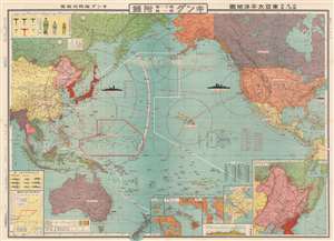
東亞太平洋地圖 / 非常時國防一覽 / East Asia Pacific Map / A National Defense View at a Special Time. / Hijōji kokubō ichiran tōa-taiheiyō-zu.
sold
- Digital Map Information
- Suitable for large format printing
- File Size: 78.23 MB
- File Type: ZIP / TIFF
- ICC color profile embedded
- Delivered instantly via download link
This is a fascinating and important 1935 (Showa 10) Nakata Fukuzou Pre-World War II Japanese propaganda map of the Pacific foreshadowing the Pearl Harbor attack, the Aleutian Islands Campaign, and the Philippine Campaign. Covering the entire Pacific, from the Bay of Bengal to New York and from the Bering Strait to New Zealand, this map anticipates the overarching Japanese strategy for World War II in surprising detail. (more details)