
National Geographic Society (sold)

The National Geographic Society (NGS) (January 13, 1888 - Present) is one of the largest non-profit educational and scientific organizations in the world. Headquartered in Washington, D.C., The National Geographic Society focuses on geography, natural scent, archaeology, the study of world culture and history, and the promotion of environmental and historical conservation. Its founding principle 'to increase and diffuse geographic knowledge' still guides the Society to this day. The organization's official magazine, National Geographic has been published continuously since 1888. It was published worldwide in almost forty languages as of 2015. The Walt Disney Company acquired a controlling interest in the magazine in 2019.
Details plans to rejuvenate the National Mall and the surrounding area.
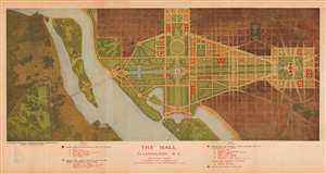
The Mall. Washington D.C. Plan Showing Building Development to 1915 in Accordance with the Recommendations of the Park Commission of 1901.
sold
- Digital Map Information
- Suitable for large format printing
- File Size: 17.98 MB
- File Type: ZIP / TIFF
- ICC color profile embedded
- Delivered instantly via download link
This is a 1915 National Geographic Society city plan or map of the National Mall in Washington, D.C. Depicting the region from Arlington National Cemetery to the Library of Congress and from Lafayette Square to where the Thomas Jefferson Memorial is today. Twenty-one buildings are illustrated around the Mall. Some, including the White House (No. 2), the Capitol Building (No. 1), the Library of Congress (No. 6), and recently constructed House and Senate office buildings, are shaded red, indicating that they had been built before 1901 or had been built between 1901 and 1915. Other buildings, such as buildings for the Departments of Justine, States, Commerce, and Labor, were proposed as part of the McMillan Plan, upon which this map was based. (more details)
Details plans to rejuvenate the National Mall and the surrounding area.
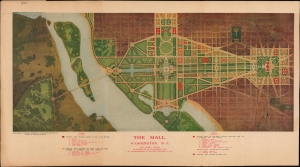
The Mall. Washington D.C. Plan Showing Building Development to 1915 in Accordance with the Recommendations of the Park Commission of 1901.
sold
- Digital Map Information
- Suitable for large format printing
- File Size: 14.5 MB
- File Type: ZIP / TIFF
- ICC color profile embedded
- Delivered instantly via download link
This is a 1915 National Geographic Society city map of the National Mall in Washington, D.C. Depicting the region from Arlington National Cemetery to the Library of Congress and from Lafayette Square to where the Thomas Jefferson Memorial is today. Twenty-one buildings are illustrated around the Mall. Some, including the White House (No. 2), the Capitol Building (No. 1), the Library of Congress (No. 6), and recently constructed House and Senate office buildings, are shaded red, indicating that they had been built before 1901 or had been built between 1901 and 1915. Other buildings, such as buildings for the Departments of Justine, States, Commerce, and Labor, were proposed as part of the McMillan Plan, upon which this map was based. (more details)
Envisioning the McMillan Plan.
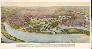
The Ultimate Washington.
sold
- Digital Map Information
- Suitable for large format printing
- File Size: 21.2 MB
- File Type: ZIP / TIFF
- ICC color profile embedded
- Delivered instantly via download link
A lovely 1915 bird's eye view of Washington, D.C., originally drawn by architect Francis L. V. Hoppin and republished in National Geographic. Among other features, it presents a view of the nation's capital (here dubbed 'Ultimate Washington') as envisioned by the McMillan Plan, a never-fully-realized scheme to remake and beautify the city. (more details)