
Netherchit, John B. (sold)

John B. Netherchit (fl. c. 1835 - 1855) was a London based lithographer active in the middle part of the 19th century. Netherchit was based at 23 King William Street, West Strand. His work is often associated with missionary publications.
Illustrates the support of European Missionaries for the Repubic of Texas before any offical recognition.
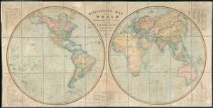
Missionary Map of the World Distinguishing the Stations of all Protestant Missionary Societies.
sold
- Digital Map Information
- Suitable for large format printing
- DPI: 600
- File Size: 84.72 MB
- File Type: ZIP / TIFF
- ICC color profile embedded
- Delivered instantly via download link
This is a rare and enormous 1838 missionary map of the world by John B. Netherchit and the Church Missionary Society. The map, published at the down of the Victorian Era, covers the world in a dual hemisphere projection and is noteworthy for its in-depth presentation of the global protestant missionary situation, and its early and significant support for the nascent Republic of Texas, declared just 2 years prior. Keyed at the corners and at bottom center, there is elaborate coding system identifying 19 different missionary societies and their stations throughout the globe, providing an outstanding overview of Protestant Missionary activity in the early-middle 19th century. Many remote towns and indigenous villages that do not commonly appear on other maps are noted here - suggesting deep knowledge of geography drawn from unique missionary sources. (more details)