
Pikowski, Michael (sold) (מיכאל פיקובסקי)

Michael Pikowski (מיכאל פיקובסקי; June 7, 1866 - October 21, 1943) was a Russian-born Israeli printer. Born in Elizabethgrad in the Russian Empire (now Kropyvnytskyi, Ukraine), Pikowski attended a Russian gymnasium before moving to Vienna to learn the printing trade. He then retuned to Ukraine, opening a printshop in Odessa specializing in zincography and editing a newspaper. In 1924, he moved to Jerusalem and established a new printshop, also publishing a bi-weekly paper titled Polygraph Pages (דפים פוליגרפיים). In Jerusalem, he published a wide variety of maps, particularly of Palestine and locales therein. Many of the firm's publications were for the Mandatory Press Office of the British government of Mandatory Palestine, but at night the shop secretly printed works for the Zionist cause. Underneath the shop was a secret headquarters of the Haganah Zionist militia. After Michael's death, his son Emil took over the firm. After the founding of the State of Israel, the firm continued to print works for the new government and was also the first to publish the Isiah Scroll, one of the Dead Sea Scrolls. The printshop continued to operate until 1997, with its last owner being Yeshayahu Atia, a longtime employee.
AKA: מיכאל פיקובסקי
Mandatory Period Jerusalem.
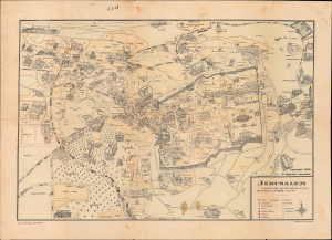
Jerusalem / Jerusalem Pictorial Plan.
sold
- Digital Map Information
- Suitable for large format printing
- Full resolution TIFF file
- ICC color profile embedded
- Delivered instantly via download link
This is a scarce 1930 pictorial map of Jerusalem prepared by Spyro Spyridon and printed by Michael Pikovsky. The map depicts the city during the middle of the period of the British Mandate with handwritten annotations likely made by a member of the Irgun paramilitary group that date to the period when the city was besieged in May 1948 during the Arab-Israeli conflict. (more details)
Era of Independence.
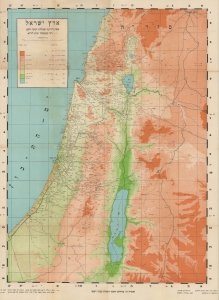
ארץ ישראל מפה לידיעת המולדת לנער ולעם / [The Land of Israel Map for Knowledge of the Homeland for the Youth and the People].
sold
- Digital Map Information
- Suitable for large format printing
- File Size: 29.2 MB
- File Type: ZIP / TIFF
- ICC color profile embedded
- Delivered instantly via download link
A scarce c. 1946 Hebrew-language map of Mandatory Palestine / Eretz Israel edited by David Benvenisti and Ben-Zion Luria. (more details)
Visualizing the Indochina Wars in Israel.
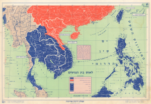
This is a c. 1960 map of Southeast Asia produced by the Israeli cartographic firm Carta for Ben-Zion Luria's Aṭlas Yedi'ot Aharonot. It highlights the Cold War ideological struggles in the region, particularly the Laotian Civil War (1959 - 1975). (more details)