
1930 Spyridon Pictorial Map of Jerusalem, Mandatory Palestine

Jerusalem / Jerusalem Pictorial Plan.
Mandatory Period Jerusalem.
- Digital Map Information
- Suitable for large format printing
- Full resolution TIFF file
- ICC color profile embedded
- Delivered instantly via download link
Mandatory Period Jerusalem.
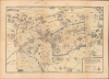
This is a scarce 1930 pictorial map of Jerusalem prepared by Spyro Spyridon and printed by Michael Pikovsky. The map depicts the city during the middle of the period of the British Mandate with handwritten annotations likely made by a member of the Irgun paramilitary group that date to the period when the city was besieged in May 1948 during the Arab-Israeli conflict.A Closer Look
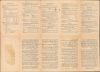
The map covers the main portion of Jerusalem with the Old City prominently outlined by its historic walls. Churches, synagogues, mosques, hospitals, hotels, schools, consulates, government buildings, and other features are illustrated and labeled throughout. The verso text provides extensive information for the traveler, including on travel, currency, communication, hotels, banking, and brief descriptions of major sites.Manuscript Notations
The map contains a considerable number of handwritten annotations in Hebrew, transcribing names of streets and other features labeled in English. Arrows trace what may be the movement of a person or people through the city, from the vicinity of the Hebrew University of Jerusalem on Mount Scopus to the northwest and then the southwest part of Jerusalem. A handwritten date at the top reads '15.5.48,' or May 15, 1948, during a monthslong siege and battle over the city between Arab and Jewish forces. Although we cannot clearly connect the movement traced here with any specific event, it could easily have represented the movement of Jewish refugees to the relative safety of the western part of the city, and indeed the Jewish settlements of Atarot and Neve Yaakov just north of Jerusalem were evacuated in mid-May 1948.Alternatively, as the map likely belonged to the political activist Yitzhak Moshe Emmanuel (see below), who at this time was a student at the Hebrew University (where the arrows begin) and a member of the Zionist paramilitary group Irgun, the arrows may reflect Irgun operations in the city at the same time, which included a failed bid to take over the Arab (eastern) part of the city to alleviate the Arab Legion blockade of the Jewish Quarter of the Old City.
The Battle of Jerusalem
The Battle for Jerusalem in 1948 was a pivotal and protracted conflict that defined the geography of the modern city. Following the UN Partition Plan, Jerusalem was intended to be an international corpus separatum but instead became a primary battleground between Jewish and Arab forces. For the city's Jewish population of approximately 100,000, the conflict was defined by a brutal siege that began in late 1947. Arab irregulars and the Transjordanian Arab Legion severed the main highway from Tel Aviv, the city's only lifeline for food, water, and fuel. By the spring of 1948, the Jewish quarters faced severe rationing. The legendary 'Bab al-Wad' (Gate of the Valley) became a graveyard for supply convoys attempting to break through the blockade.The defense and eventual offensive maneuvers of the Jewish community were spearheaded by various paramilitary organizations with often conflicting ideologies. The Haganah, the mainstream Zionist militia, led the primary defense and organized the daring 'Operation Nachshon' in early-mid April 1948 to open a corridor to the city. However, more militant underground groups, the Irgun and Lehi (Stern Gang), operated independently, at times collaborating with the Haganah and at others pursuing their own aggressive strategies. The most controversial moment involving these groups was the Deir Yassin massacre on April 9, which significantly accelerated the flight of the Arab population and heightened the intensity of the urban warfare that followed. Arab units were similarly divided between regulars (the Arab Legion, commanded by British officers), paramilitaries, and local militias.
The human cost of the battle was marked by massive waves of refugees on both sides. In eastern Jerusalem, the historic Jewish Quarter of the Old City fell to the Arab Legion in May 1948, leading to the expulsion of its residents and the destruction of ancient synagogues. Simultaneously, tens of thousands of Palestinian Arabs fled or were displaced from neighborhoods in West Jerusalem as Jewish forces consolidated control over the western half of the city. This demographic shift resulted in a divided city partitioned by the Green Line, akin to East and West Berlin, a status that would persist until the Six-Day War in 1967.
Mandatory Period Jerusalem (1917 - 1947)
The British captured Jerusalem from the Ottomans on December 11, 1917, drastically altering the historical trajectory of the city. Under the British 'Mandate,' the city grew significantly, especially outside of the Old City, and took on many characteristics of British imperial outposts elsewhere. New public institutions (universities, hospitals) were built and new regulations put into place around urban planning and architecture.However, the British also had to contend with the maddening issue of inter-communal violence. The Balfour Declaration had all but required the Mandate to encourage the immigration of Jews from Europe and elsewhere, a disproportionate number of whom settled in Jerusalem. Even before the Mandate, Jewish migrants had settled in the city in significant numbers, but Ottoman land records were spotty, leaving the British with the task of sorting out competing property rights.
The result was that the Mandate period was consumed with policing violence between Jews and Arabs, as well as supporting Zionism in principle while also opposing the more ardent, armed Zionist groups seeking an independent Israel. These contradictions in British policy set the stage for the post-World War II creation of the State of Israel and for the continued disputes over its territory, which persist to the present day.
Publication History and Census
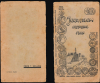
This map was prepared by Spyro Spyridon, printed by Michael Pikowski (or Pikovsky), and published by Goldberg's Press in Jerusalem in 1930. This example includes a stamp on both sides with the name and address of a previous owner, Yitzhak Moshe Emmanuel. There is a high probability that this was the hardline Zionist political activist of the same name (יצחק משה עמנואל 1927 - 2006), born and raised in Jerusalem, who was a student at the Hebrew University (and a member of the Irgun) during the 1947-48 conflict.This is the first edition of the map, while a second edition was printed c. 1935 but retained the 1930 date. The same map also appeared with a different cover, titled 'Guide map of Jerusalem, ancient and new,' starker color, and without mention of Goldberg's Press (Rumsey 16722.002), which was printed in three editions in the 1930s (also retaining the original 1930 date). All these various printings are scarce, with the present 1930 first edition, with either cover, being held by Duke University, George Washington University, Harvard University, Pennsylvania State University, the Royal Danish Library, the National Library of Israel, the Hebrew University of Jerusalem, and the David Rumsey Historical Map Collection.
Cartographers
Spyro N. Spiridon (also spelled Spyridon) (1894 - 19xx) was a Jerusalem-born engineer and cartographer. Spiridon studied electrical and civil engineering in Switzerland in his twenties and was exposed to the types of pictorial tourist maps that were popular there. After returning to Jerusalem, Spiridon had difficulty making ends meet with jobs in his chosen field, so he changed tactics and created a pictorial tourist map of Jerusalem. Spiridon's first map, published in 1930, was one of the first tourist maps of Jerusalem to employ the vignette-style views of buildings to mark popular tourist sites. He then published a panorama of Jerusalem, with editions of this map appearing in 1945, 1948, and 1953 at the very least. Further Details...
Michael Pikowski (מיכאל פיקובסקי; June 7, 1866 - October 21, 1943) was a Russian-born Israeli printer. Born in Elizabethgrad in the Russian Empire (now Kropyvnytskyi, Ukraine), Pikowski attended a Russian gymnasium before moving to Vienna to learn the printing trade. He then retuned to Ukraine, opening a printshop in Odessa specializing in zincography and editing a newspaper. In 1924, he moved to Jerusalem and established a new printshop, also publishing a bi-weekly paper titled Polygraph Pages (דפים פוליגרפיים). In Jerusalem, he published a wide variety of maps, particularly of Palestine and locales therein. Many of the firm's publications were for the Mandatory Press Office of the British government of Mandatory Palestine, but at night the shop secretly printed works for the Zionist cause. Underneath the shop was a secret headquarters of the Haganah Zionist militia. After Michael's death, his son Emil took over the firm. After the founding of the State of Israel, the firm continued to print works for the new government and was also the first to publish the Isiah Scroll, one of the Dead Sea Scrolls. The printshop continued to operate until 1997, with its last owner being Yeshayahu Atia, a longtime employee. Further Details...
Condition
Good. Wear along original fold lines. Verso repairs to fold separations. Slight loss at a few fold intersections. Manuscript notations on recto. Text on verso.
References
Rumsey 16722. OCLC 18126347, 769257790, 992581805.