
Pingree-Traung Company (sold)

Pingree-Traung Company (1911 - 1966) was a lithographic printing firm founded in San Francisco in 1911. The company operated at Battery and Green Streets, under this imprint until 1916 when it was renamed 'Traung Label and Lithography'. The firm specialized in fruit box labels and other commercial lithography and chromolithography. In 1926, they purchased the 'Stecher Lithograph Company' of Rochester, New York (founded 1887), and renamed themselves 'Stecher-Traung'. In 1966, the firm was acquired by International Paper and folded into general operations.
...with every building recognizable!
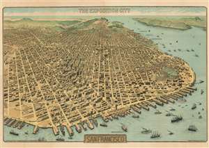
The Exposition City San Francisco.
sold
- Digital Map Information
- Suitable for large format printing
- File Size: 122.73 MB
- File Type: ZIP / TIFF
- ICC color profile embedded
- Delivered instantly via download link
An extraordinary bird's-eye view perspective view and map of San Francisco, risen from the ashes of the 1906 earthquake and fire, ready to retake the world stage by hosting of the Panama-Pacific International Exposition. The view looks westward on San Francisco from a fictional highpoint above today's San Francisco-Oakland Bay Bridge with California Street running dead center. The Embarcadero and docks appear in the foreground, while Golden Gate Park and the Pacific are recognizable in the distance. The Panama-Pacific Exposition, displayed here prospectively, appears at right, near the Golden Gate. Across the bay, in the distance, Mount Tamalpais, with a winding road ascending, is recognizable. The view presents a city fully recovered from a disaster that, just six years prior, destroyed eighty percent of the city. Cartographically the map is noteworthy as it illustrates and names nearly every single building - an astounding achievement and an invaluable record of San Francisco c. 1912. (more details)