
Plummer, George Howard (sold)

George Howard Plummer (March 8, 1868 - June 5, 1950) was an American surveyor who worked for the U.S. Geological Survey during the latter part of the 19th century and the early 20th century. He is credited with preparing many different reports and maps for the U.S.G.S. He was married to Emma Lulu Fries.
A Monumental, Detailed Map of Washington State highlighting its forestry industry, richness, and diversity.
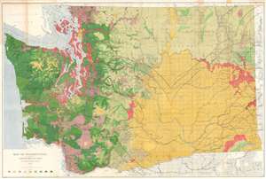
Map of Washington Showing Classification of Lands.
sold
- Digital Map Information
- Suitable for large format printing
- File Size: 150.99 MB
- File Type: ZIP / TIFF
- ICC color profile embedded
- Delivered instantly via download link
This is a large, colorful 1902 Map of Washington State showing the distribution and value of its forest lands - at the time, the primary moneymaker for the state. The map is printed in nine shades, showing unforested regions, cut and burned regions, and the density of forested areas. The map has been updated closely since its 1898 edition, showing dramatic re-growth in reserve areas - in particular, the Mount Rainier and the Olympic Jefferson Forest Reserves. Both of these had been established in 1897, and the dramatic changes shown on this map in comparison with the 1898 edition testify to the efficacy of the reserves in permitting the regrowth of heavily lumbered forest. Both of these areas would be made into National Forests in 1907. (more details)