
Proeschel, Frederick (sold)

Frederick Proeschel (March 11, 1809 - May 1, 1870) was a map maker and publisher. Born in Colmar, Haut Rhin, France, Proeschel began his professional life as an upholsterer. While working as an upholsterer, Proeschel experimented with different materials and even designed mattresses using springs. He also invented a way of manufacturing moisture-resistant bricks, which garnered him recognition from several different organizations in France. During the Revolution of 1848, Proeschel suffered substantial losses to his business, and soon left for the United States. He stayed in the U.S. until 1852 when he left for Australia, arriving in Melbourne in December of that year. By the end of July 1853, Proeschel was operating an information and labor agency in Melbourne on Little Bourke Street that operated in English, French, and German (Proeschel was fluent in all three). He also published his first map in 1853 and it detailed routes to the gold diggings in Victoria. Then he published maps of Melbourne, Collingwood, Richmond, and North Melbourne. He published his first map of Victoria in 1856. Proeschel's early maps were lithographs of modest quality. Not long after Proeschel published his first map of the gold diggings in Victoria, James Buckingham Philp (the lithographer who printed Proeschel's first work) published a new copy of Proeschel's map of the gold diggings without Proeschel's knowledge. Philp changed the title and polished the map, but it was obvious that it was copy of Proeschel's map. Proeschel was understandably furious and wrote an incensed letter to the Colonial Secretary pleading his case. Unfortunately for Proeschel, copyright law did not exist in Australia at the time, so nothing could be done to protect Proeschel's intellectual property. Then, in 1859, he published a finely engraved map of Victoria with the most up-to-date information. Several editions of this piece were published. He published his Atlas of Australasia in 1863, which cost him over three thousand pounds, a cost he likely did not recoup. While successful as a map seller, he never managed made a fortune. Proeschel left Australia in February 1864 for London to promote his work on an atlas of world exploration from the 1460s until the 1860s. Apparently this venture was unsuccessful, and he soon returned to Paris, where he again tried to promote his atlas. He published pamphlets on cholera and investment in Paris in the late 1860s and died in Paris with a mere forty francs to his name.
Victoria Gold Rush!
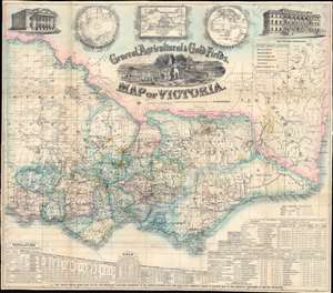
General, Agricultural, and Gold Fields Map of Victoria.
sold
- Digital Map Information
- Suitable for large format printing
- Full resolution TIFF file
- ICC color profile embedded
- Delivered instantly via download link
This is a rare 1859 Frederick Proeschel pocket map of Victoria, Australia, published to capitalize on Victoria Gold Rush emigration. Such maps were sold cheaply to hopeful prospectors who often carried them in-hand to mining and agricultural camps - the harsh conditions contributing to such maps having exceptionally low survival rate. The central cartouche engraved by D. Tulloch, illustrates Victoria's many blessings, including rich flora and fauna, excellent agricultural lands, and of course, the all-important gold mines. Herein, gold 'diggings' are highlighted throughout in brilliant yellow - offering essential data to the emigrant. In addition, the map names settlements, offers commentary on terrain, and highlights both planned and active transportation networks. For those disinclined to rough gold camp life, It also notes 'good sheep pastures'. A view of the Geelong town hall occupies the upper left, and a view of the Melbourne 'Gold Office' the upper right. Three inset maps illustrate, from left to right, the southern hemisphere, the world on a Mercator projection (with Australia at the center) and Australasia. Statistics are included along the bottom border, with particular attention to 'principal gold field townships or diggings', the values of gold extracted from specific fields, Victoria's exports, and Great Britain's exports. (more details)