
Renouard, Jules (sold)

Jules Renouard (February 13, 1798 - February 20, 1854) was a prosperous French book dealer, editor, publisher, and bibliographer. Renouard was born in Paris, the son of revolutionary, industrialist-politician, and book dealer Antoine-Augustin Renouard (1765 - 1853). He studied at the Lycée Louis-le-Grand. Graduating he relocated to London to peruse a career in banking, but by 1826, inherited his fathers book business. Renouard was a founding member of the Cercle de la Librairie (Book Dealers' Association) founded in 1847.
'An important map.' - Wheat
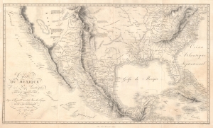
Carte Du Mexique et des Pays Limitrophes Situes Au Nord et a l'est Dressee d'apres la Grande Carte de la Nouvelle Espagne De Mr. A. De Humboldt et d'autres Materiaux par J.B. Poirson.
sold
- Digital Map Information
- Suitable for large format printing
- DPI: 600
- File Size: 70.19 MB
- File Type: ZIP / TIFF
- ICC color profile embedded
- Delivered instantly via download link
A seminal 1811 / 1827 map of Mexico and the American West by Alexander von Humboldt. Humboldt, who during his lifetime was considered the 'world's greatest living man,' composed this map during his 1803 sojourn in Mexico. Though often playing second fiddle to Humboldt's more regional Carte Generale du Royaume de la Nouvelle Espagne, published in the same volume, this map is a cartographic achievement in its own right and, as Wheat notes 'an Important Map.' (more details)
The Earth is round!
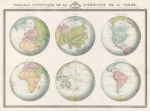
Tableau Synoptique de la Sphéricité de la Terre ou Plan en perspective des principaux Aspects du Globe Terrestre, pris dans les deux Hémisphères, et reproduits sur une plus grande échelle dans les Cartes suivantes, d'après la Projection Orthographique.
sold
- Digital Map Information
- Suitable for large format printing
- File Size: 33.04 MB
- File Type: ZIP / TIFF
- ICC color profile embedded
- Delivered instantly via download link
This is the 1860 F. A. Garnier map of the Earth in a visual summary of the Earth's sphericity from multiple angles. (more details)