
Ritter, Franz (sold)

Franz Ritter (15??-1641), also known as 'Franciscum,' was a German mathematician, cartographer, and astronomer active in Nuremberg during the first half of the 17th century. In cartographic circles Ritter is admired for his introduction of an unusual gnomonic projection. Ritter's took no apprentices and consequently many of his cartographic innovations were forgotten after his death.
Ritter's outstanding 'Sundial Map' linking time and geography.
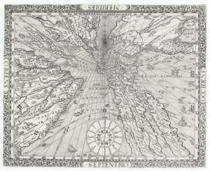
[Untitled Sundial Map]
sold
- Digital Map Information
- Suitable for large format printing
- DPI: 300
- File Size: 6.47 MB
- File Type: ZIP / TIFF
- ICC color profile embedded
- Delivered instantly via download link
A spectacular map of the utmost curiosity and unparalleled cartographic coolness, this is Franz Ritter's untitled 1640 map of the world on a polar gnomonic projection – often referred to as the 'Sundial Map.' Projected from the North Pole, Ritter's map covers ... (more details)