
Rogg, Gottfried (sold)

Gottfried Rogg (1669-1742) was an Augsburg goldsmith, engraver and publisher. He was known for his decorative engraving, in particular having engraved a large number of the maps for Matthias Seutter’s atlases.
1734 Map of the Holy Land.with Beautifully Engraved Bible Scenes
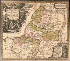
Regio Canaan Seu Terra Promissionis, Postea Iudaea Vel Palestina Nominata, Hodie Terra Sancta Vocata : Quae Olim XII Hoc Autem Aevo In VI Provincias Distincta Est Iuxta Recentissimas et Accuraissimas Descriptiones Adornata Per Matth. Seutter, Sac. Caes. Maj. Geographo Augusta.
sold
- Digital Map Information
- Suitable for large format printing
- DPI: 600
- File Size: 36.81 MB
- File Type: ZIP / TIFF
- ICC color profile embedded
- Delivered instantly via download link
This 1734 Seutter map of the Holy Land reproduces the authoritative cartography of Nicolas Sanson with the bold, richly decorative cartouches of Seutter’s master engraver, Gottfried Rogg. The primary map shows Judaea, divided into the territories of the 12 Tribes. The tribal regions are distinguished from one another in rich, period wash and outline color. Mountains and forests are shown pictorially. The map uses a key to distinguish Royal Cities, Cities of Refuge, and Levite Cities from each other. It includes, also, cities the Bible records were destroyed: Sodom, Gomorrah, and Seboim. All of these can be found within the bounds of the Dead Sea. The superbly engraved cartouche shows a New Testament scene of Christ drawing a demon - appearing in the form of a wriggling, winged creature in a puff of smoke - out of the mouth of a possessed man, while a crowd of onlookers gasp in amazement. An inset map in the lower right shows the track of the Israelites out of Egypt and into Canaan: Moses appears to the right of the inset, and above is a depiction of Numbers 21:4-9 in which the Israelites gather close to a brazen serpent, set up by Moses to protect them from the flying fiery serpents assailing them. The presence of this allegory here is not accidental: it is placed in support of the crucifixion scene appearing in the background of the main cartouche (in John 3:14-16 an explicit comparison was drawn between the raising of the Brazen Serpent and the Crucifixion.) (more details)