
Roullier, Gustave Augustus (sold)

Gustave Augustus Roullier (August 14, 1849 - April 21, 1910) was a civil engineer and surveyor based in Flushing, Queens County, New York, who produced several early survey and plat maps of the northeastern part of Queens County, including Flushing, College Point, Whitestone, Corona, and Murray Hill. Of French descent (his grandfathers on both sides were officers under Napoleon), Roullier was born in New York City but his family moved to Flushing (then well outside of New York City) during his childhood. He left to attend the Rensselaer Polytechnic Institute but returned to New York City after graduation. In the early 1870s, he married Mary Martin, with whom he had four daughters, and also enlisted in the New York National Guard, where he eventually rose to the rank of lieutenant-colonel. He also returned to Flushing shortly afterwards and became the most prominent civil engineer in the fast-growing suburb, helping to lay out its street grid and serving as Water Works and Street Commissioner between 1880 and 1888. He then turned to surveying work for private clients, particularly real estate developers. Roullier's later life took a tragic turn, however, after his wife died in 1897 and as his health and business faltered. He committed suicide in his office at 45 Main St. in Flushing, near the center of the town he played a large hand in building.
Flushing on the Eve of Consolidation.
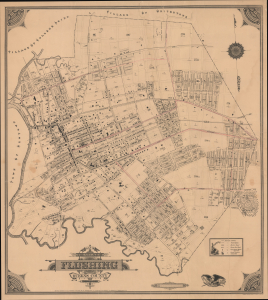
Map of the Village of Flushing Queens County New York.
sold
- Digital Map Information
- Suitable for large format printing
- File Size: 42.12 MB
- File Type: ZIP / TIFF
- ICC color profile embedded
- Delivered instantly via download link
This is Gustave Roullier's extremely rare 1894 city map of Flushing, now part of the borough of Queens in New York City. Replete with ghosted streets and planned developments, it demonstrates the rapid growth of the village at the end of the 19th century and the eve of consolidation into New York City. (more details)