
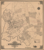
1894 Roullier Plan or Map of Flushing, Queens, New York City


This item has been sold.
Map of the Village of Flushing Queens County New York.
Flushing on the Eve of Consolidation.
- Digital Map Information
- Suitable for large format printing
- File Size: 42.12 MB
- File Type: ZIP / TIFF
- ICC color profile embedded
- Delivered instantly via download link
Flushing on the Eve of Consolidation.
This is Gustave Roullier's extremely rare 1894 city map of Flushing, now part of the borough of Queens in New York City. Replete with ghosted streets and planned developments, it demonstrates the rapid growth of the village at the end of the 19th century and the eve of consolidation into New York City.A Closer Look
The map covers the main part of the village of Flushing, bounded on the south by the Kissena Creek, on the west by Flushing Creek, the towns of College Point and Whitestone in the north, and by unincorporated territory to the east. Individual blocks and lots are noted throughout, including farms (with their acreage noted) that were being reduced or eliminated to make way for the new street grid. In fact, much of the street grid outside of downtown Flushing is ghosted in here, as are some structures, such as the track of the Flushing Driving Association at top-right. Waterways, including Flushing Creek, are traced, some of which lie under the planned street grid. As is the case with other New York City boroughs, many of these street names were later changed, resulting in the widespread use of numbered streets and avenues. However, some remain from the time of this map, including Main St. and Sanford Ave., while others are easily recognizable despite their names changing, such as Broadway here, which became Northern Blvd. Though eminently practical, the map also includes fine aesthetic touches, such as the intricate patterns of the compass rose and in the corners of the border.In addition to blocks of residential and commercial space, and churches, several institutions are labelled, including Flushing High School, the first free public high school in what is now New York City, which opened in 1875 and relocated to its current location on Northern Blvd. in 1915. The Flushing Athletic Club no longer exists, but it was prominent at the time, including having established the Pomonok Country Club in an area just south of that seen here (near today's Queens College), which was considered among the best in the New York metropolitan area and hosted the PGA Championship in 1939.
Particular attention is paid to sewers, water mains, and fire hydrants, reflecting Roullier's background as Flushing's Water Works and Street Commissioner (see biography below). Both steam railroad (the Long Island Rail Road) and electric rail (streetcars) are traced. Manuscript annotations in red are not explained but are likely references to planned streetcar lines.
Historical Context
In the late 19th century, Flushing underwent a profound transformation from a collection of quiet farms and gardens into a burgeoning suburban hub; a prestigious residential enclave for wealthy New Yorkers seeking respite from the density of Manhattan. The development of the Long Island Rail Road (LIRR) and enhanced ferry services were the primary engines of this growth, reducing travel times to the industrial core of New York City. By the 1870s and 1880s, the ease of commuting allowed for a demographic shift, with Flushing attracting a professional middle class. This period also saw the establishment of vital civic institutions, including Flushing High School, mentioned above, and the Flushing Free Library (established in 1884, now part of the Queens Library), the second-oldest free public library in today's New York City.The close of the century was marked by the pivotal political shift of the Consolidation of 1898 (the result of a referendum in 1894, the same year as this map's production), in which Flushing was incorporated into the City of Greater New York as part of the Borough of Queens. While this move brought significant infrastructure improvements, such as paved roads, it was opposed by the majority of locals in the 1894 vote and signaled the end of Flushing's era as an autonomous village. In the following decades, the already rapid urbanization underway only intensified, with the planned street grid seen here enacted and the remaining farmland filled in by homes and businesses, many of which themselves were replaced by larger brick structures in the 1920s - 1940s, particularly after the arrival of the IRT Flushing Line (now the 7 train of the NYC Subway).
Publication History and Census
This map was prepared by Gustave A. Roullier and printed by Robert Alexander Welcke in 1894. It can be considered the definitive map of Flushing of its era, with others either being atlas maps (such as our earlier listing Flushing-beers-1873) or cadastral maps of specific neighborhoods, usually produced for real estate developers (often by Roullier himself). This map is very rare, with only one other known example held by the Library of Congress.Cartographers
Gustave Augustus Roullier (August 14, 1849 - April 21, 1910) was a civil engineer and surveyor based in Flushing, Queens County, New York, who produced several early survey and plat maps of the northeastern part of Queens County, including Flushing, College Point, Whitestone, Corona, and Murray Hill. Of French descent (his grandfathers on both sides were officers under Napoleon), Roullier was born in New York City but his family moved to Flushing (then well outside of New York City) during his childhood. He left to attend the Rensselaer Polytechnic Institute but returned to New York City after graduation. In the early 1870s, he married Mary Martin, with whom he had four daughters, and also enlisted in the New York National Guard, where he eventually rose to the rank of lieutenant-colonel. He also returned to Flushing shortly afterwards and became the most prominent civil engineer in the fast-growing suburb, helping to lay out its street grid and serving as Water Works and Street Commissioner between 1880 and 1888. He then turned to surveying work for private clients, particularly real estate developers. Roullier's later life took a tragic turn, however, after his wife died in 1897 and as his health and business faltered. He committed suicide in his office at 45 Main St. in Flushing, near the center of the town he played a large hand in building. Further Details...
Robert Alexander Welcke (November 24, 1848 - January 27, 1936) was a photolithographer active in New York in the latter part of the 19th century and early 20th century. Welcke was born in Wronke, today in Poland, but then part of Prussia. He emigrated to New York City in 1869. After settling, Welcke entered the lithography business with his brother, Edward Welcke, who had arrived a decade earlier. After a split between the brothers during the economic depression of the late 1870s, Robert Welcke continued in business on his own. Welcke's firm, Robert A. Welcke Offset Company, was based at 176 William Street. His corpus ranges from real estate maps of New York and Connecticut to illustrations on Flemish Renaissance interiors to government maps and brochures to decorative sheet music covers. Following Welcke's death, the firm was taken over by his daughter, Olga Welcke, who, alongside William Jugens, managed it until the outbreak of World War II (1939 - 1945). Further Details...
Condition
Very good. Even toning. Some edge wear. Light annotations. Original linen backing.
References
Library of Congress, G3804.N4:2F5 1894.R6.