
Ruyter, Baltasar (sold)

Baltasar Ruyter (fl. c. 1680 - 1710) was a Dutch engraver active in the late 17th and early 18th centuries. His work is most commonly associated with Pierre Mortier, and the firm of his son Jean Covens and Cornielle Mortier (Coven's and Mortier). Little is known of his life.
Large early nautical chart of the world showing Californai as an island and embryonic Australia.
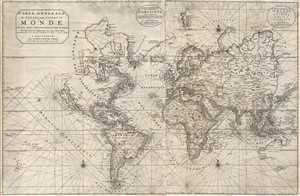
Carte Generale de Toutes Les Costes Du Monde et Les Pays Nouvellement Decouvert, Dresse sur les Relations les Plus Nouvelles Et Principalement sur la Carte que Monsieur N Witsen, a done au Public. / Carte Generale des costes de L'Amerique sur L'Ocean, et les Pays Nouvellement decouvert, Dresse sur les Relations les plus Nouvelles. / Partie Orientale du Monde, qui Contiennent L'Europe, L'Asie, et L'Afrique.
sold
- Digital Map Information
- Suitable for large format printing
- DPI: 300
- File Size: 19.72 MB
- File Type: ZIP / TIFF
- ICC color profile embedded
- Delivered instantly via download link
This is Pierre Mortier's 1703 large format nautical chart of the world on a Mercator Projection. Centered on the Atlantic, this impressive chart covers the entire world as it was then known. Rhumb lines appear throughout and the coastlines are heavily labeled ... (more details)
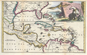
Kaarte Van de Golf van Mexico en het Zuyd-America waar in Porto-Bello en Panama aangewezen warden.
sold
- Digital Map Information
- Suitable for large format printing
- Full resolution TIFF file
- ICC color profile embedded
- Delivered instantly via download link
Engraved by Balthasar Ruyter, this is an extremely rare and highly unusual 1747 map of Mexico, the Caribbean, the West Indies and Florida. Covers from roughly Michoacán Mexico, west to Surinam, north as far as modern day Virginia and south as far as modern day ... (more details)