
Sandoz, Ernest C. (sold)

Ernest C. Sandoz (1830 - April 6, 1908) was a Swiss-American draftsman and cartographer. He was nephew of the geologist and geographer Arnold Henry Guyot, and emigrated to the United States with his uncle, mother and grandmother in about 1848. While nothing is known of his early education, it is clear that he followed Guyot as long as his uncle lived, working with him throughout his career. Guyot, in his last will and testament, bequeathed rights to his wall maps and the map of the Catskills to Sandoz ‘who has been, during so many years, for me as an affectionate son and a constant help.’ Sandoz is credited with no fewer than twenty maps, the vast majority of which were under Guyot’s direction. In spite of this, Sandoz’s draftsmanship does not appear to have been his only labor: his September 14, 1863 draft registration lists his profession as ‘Gardiner.’(sic.)
The First Map Specifically of the Catskill Mountains
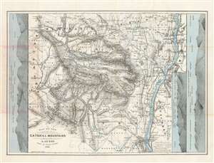
Map of the Catskill Mountains. Surveyed by A. Guyot. Drawn by Ernest Sandoz. 1880.
sold
- Digital Map Information
- Suitable for large format printing
- File Size: 28.54 MB
- File Type: ZIP / TIFF
- ICC color profile embedded
- Delivered instantly via download link
This is Arnold Guyot's 1879 map of the Catskill Mountains. It is the only early map to focus specifically on the range, and the very first to accurately depict the region, and provide a useful tool for traveling it. The far-ranging Swiss geologist was an inveterate trekker, and his surveys of not only the Catskills but also the lion's share of the Appalachian mountain range were executed personally, on foot. His map provides the elevation above sea level for virtually every peak shown on the map. Prior to his surveys, misconceptions about the Catskills abounded. For example, 'High Peak' had been so named based upon the assumption that it was the highest in the range: Guyot's survey took him far deeper into the mountains than prior surveys, however, and his cataloguing of the less-accessible mountains ranks High Peak only twenty third. Guyot, as he did in his other maps of the Appalachians, resolved epidemic disagreements about place names by relying on the terminology used by the denizens of the region he was mapping - diverging from this discipline on rare occasions where clarity in language called for it (for example, swapping Round Top with High Peak to reflect the reality that Round Top was the higher of the two.) (more details)