
Savinkov, Alexsander Dmitrievich (sold)

Alexsandr Dmitrievich Savinkov (1767 - c. 1849) was a Russian cartographer and engraver active in the late 18th and early 19th centuries. Little is known of his early life and education, but was born into a military family and joined the Geographical Department of the Tzar's Cabinet in 1787. There he mastered engraving under K. F. Forlov. He engraved six of the 44 maps in the 1792 Russian Atlas. He was recommended for elevation to master engraver in 1797, along with fellow engravers K. Ushakov, T. Mikhailov, and A Belousov. In the following year, 1798, Savinkov was transferred to the Map Depot where he became involved in several national mapping projections. He remained with the map depot until 1811, engraving several atlas maps (1802), a plan of St. Petersburg (1804), a postal map of the Russian Empire (1804), and atlas (1807) and a large-scale general map of the empire (1809). Throughout 1811, he severed as Commissioner of the Provisions Service, beginning his mos prolific period as a map publisher and engraver. In March of 1812, he became a member Tzar Alexander I's retinue in the quartermaster's unit, where he remained until 1818. At this time, he transferred to the Marine Printer, where he produced multiple maps until 1822. At this time, he retired with the rank of Court Councilor. While he officially retired, at just 55, he continued to publish maps for the subsequent 20 years, with his last known map being a plan of St. Petersburg, 1841. He lived at 51 Basseynaya, and had estate in Vyshnevolotsk District, where he maintained 17 serfs.
The Russian Empire at its height of expansion just before the Napoleonic Invasion.
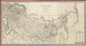
ГЕНЕРАЛЬНАЯ КАРТА РОССIЙСКОЙ ИМПЕРIИ HA ПЯТДЕСЯТЪ ГУБЕРНIЙ РАЗДЂЛЕННОЙ, съ ПОКАЗАНIЕМЪ СОСЕДСТВЕННЫХЪ ВЛАДЂНІЙ и большихъ дорогъ. / A General Map of the Russian Empire Divided into the Fifty Provinces, Showing Neighboring Domains and Highways.
sold
- Digital Map Information
- Suitable for large format printing
- DPI: 600
- File Size: 112.48 MB
- File Type: ZIP / TIFF
- ICC color profile embedded
- Delivered instantly via download link
An exceptionally rare 1809 large-format map of the Russian Empire by Alexsandr Dmitrievich Savinkov. This is the largest and most important map published during Savinkov's tenure at the Saint Petersburg Imperial Map Depot. Presented on a conic equidistant projection, Savinkov's map covers the Russian Empire in all of its expansiveness, from Finland, annexed into Russia in the year this map was made, to Russian Alaska, and from the Arctic to Mongolia. It is dedicated to Savinkov's patron, Tsar Alexander I or Alexander Pavlovich (1777 - 1825), who ruled from 1801 to 1825. The whole exhibits Savinkov's distinctive and exceptional fine engraving style. (more details)