
Serra, D. J. M. (sold)

D. J. M. Serra (fl. 1890) was the Spanish author of a trio of city plans proposing the redevelopment of the old city of Barcelona along modern lines. He appears to be credited with no other published work, and there is no bibliographical record for him.
Plotting the Urban Renewal of Barcelona's Ciutat Vella.
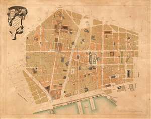
Ordenanzas Municipales Apendice No. 1 (c) Plano de la Reforma Interior de la Ciudad de Barcelona Aprobado por Reales Decretos de 12 de Abril de 1887 y 14 de Julio de 1889. 1891.
sold
- Digital Map Information
- Suitable for large format printing
- File Size: 41.16 MB
- File Type: ZIP / TIFF
- ICC color profile embedded
- Delivered instantly via download link
This rare 1891 map of Barcelona's Old City, or Ciutat Vella, captures a moment during the rapid urban renewal that took place in Barcelona in the latter half of the 19th century. The plan narrowly focuses on the Ciutat Vella, and superimposes (in color) the proposed layout over the convoluted warren of streets characterizing the old city. The edge of the plan hints at Barcelona's newly instituted grid of octagonal blocks, with which the planned new arrangement of streets in the old city were intended to be consonant. That grid had been implemented in the surrounding Eixample district after 1860 on the plan of Ildefons Cerdà i Sunyer; Cerdà's plan, however, had not been applied to this, the oldest part of the city. Despite the removal of the medieval city walls, the claustrophobic layout of the Ciutat Vella remained untouched by the redevelopment apparent on the rest of the plan: hence the purpose of this plan's publication. In 1891, in response to royal decrees of April 12, 1887 and July 14, 1889, A municipal ordinance was issued to plan the radical reconstruction of the old city. The ordinance was accompanied by an appendix of three plans: one of the entire Eixample district surrounding Barcelona, one of the Municipality of Barcelona itself, and this present work, focused specifically on the Ciutat Vella, to illustrate the planned radical reconstruction of the city center. All three are credited to one D. J. M. Serra, and were executed in chromolithograph by the Barcelona photolithographer Thomas and Co. All three plans appear to exist in a single edition. (more details)
A superbly detailed plan of Barcelona.
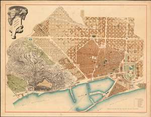
Ordenanzas Municipales Apendice No. 1 (b) Plano del Término Municipal de Barcelona. 1891.
sold
- Digital Map Information
- Suitable for large format printing
- File Size: 30.66 MB
- File Type: ZIP / TIFF
- ICC color profile embedded
- Delivered instantly via download link
This rare 1891 map of Barcelona chronicles the rapid pace of urban renewal in the city that took place in the latter half of the 19th century. The plan focuses on the municipality of Barcelona. It is oriented to the northwest, with the city's port and the Mediterranean Sea along the bottom of the lithograph. To the south of the city, the castle and park of Montjuïc are shown with their topography elegantly depicted in hachure. \To the west and north, Barcelona's characteristic grid of octagonal blocks can be seen filling up. This grid was implemented here and in the surrounding Eixample district after 1860 on the plan of Ildefons Cerdà i Sunyer, which was a process that had accelerated after the Universal Exposition of 1888. The development of the Parc de la Ciutadella and the development of La Barceloneta was also part of the 1888 Exposition, and is new on this plan. Although unpopular at first, Cerdà's plan attained enough support that the reconstruction began in earnest. Eventually, Barcelona became a hub of modernism, giving rise to the work of Art Nouveau architects like Antonio Gaudi. Today, Barcelona is one of the few old European cities that exhibits a comprehensive central plan and, due to Cerdà's vision, is considered one of Europe's most beautiful metropolises. (more details)