
Shober, Charles (sold)

Charles Shober (February 1831 - c. 1900) was a German-American lithographer and painter. Shober was born in Germany and immigrated to the United States in 1854. He established himself in Philadelphia, at 17 Minor Street, where fellow lithographers and map engravers George Worley and Benjamin Mathias, also worked. His first lithograph in America appeared in an 1855 issue of The Horticulturist. In 1857, he partnered with Charles Reen to establish 'Reen and Shober' at 5 South Sixth Street, Philadelphia. The partners relocated their business to Chicago (106 Lake Street) in 1859. Reen left the firm in 1859 and Charles took a new partner, August Roth, printing under the imprint of 'Charles Shober'. They met with considerable success, until 1871, when like many Chicago businesses, the Great Fire laid them low. After the fire, he took over management and partial ownership of the Chicago Lithographic Company, which had been founded some years earlier by Louis Kurtz and Edward Carqueville. Kurtz's interest in the firm was acquired by Shober and it was renamed 'Charles Shober and Company'. Sometime after 1876, the firm's name changed to 'Shober Lithograph Company', and then in 1877, to 'Shober and Carqueville Lithograph Company'. Despite infighting, the firm prospered, printing views, posters, maps, trade cards, and sheet music. In 1887, after a prolonged dispute with Carqueville, Shober left the firm. He traveled briefly then took a position as president of the Chicago Bank Note Company. Shober's son died in a tragic suicide in 1896, after which, Shober seems to have vanished from professional life. He appears in the Chicago directory as late as 1900.
View of Chicago in the year of its founding!
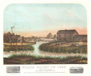
Wolf's Point in 1833.
sold
- Digital Map Information
- Suitable for large format printing
- File Size: 29.24 MB
- File Type: ZIP / TIFF
- ICC color profile embedded
- Delivered instantly via download link
This is a rare 1867 view of Wolf's Point, Chicago, as it appeared near sunset on a summer day in 1833, the year of Chicago's founding. Located at the confluence of the North, South and Main Branches of the Chicago River, Wolf's Point is the earliest site of major development in Chicago, where the city's first shops, taverns, hotels, and theaters were located. Here, Wolf Point Tavern appears on the left, at the time under the management of William Walters (1833 – 1836), with its famous 'wolf' flag. On the opposite bank of here river, a two-story building and adjoining log cabin, possibly represent Miller’s Tavern and store. In the background a simple plank bridge crosses the Chicago River. The foreground reveals a grassy riverside, on which men and women fish, picnic, and generally frolic. Although issued just 34 years after the founding of Chicago, this view already paints the city's early days in the warm tones of nostalgia. (more details)
The second earliest view of Minneapolis.
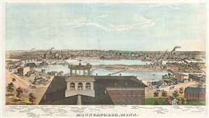
Minneapolis, Minn.
sold
- Digital Map Information
- Suitable for large format printing
- File Size: 29.99 MB
- File Type: ZIP / TIFF
- ICC color profile embedded
- Delivered instantly via download link
A stunning 1874 chromolithograph view of Minneapolis by George H. Ellsbury and Vernon Green. This image is the second earliest specific printed view of Minneapolis, following only the Hageboeck view of 1872. The view looks westwards over the Mississippi River towards Minneapolis. The large building in the foreground sporting an angelic wind vane is the observation tower of the Winslow House Hotel, which in the year this view was issued became the founding structure of Macalester College. The original span of Hennepin Avenue Bridge, the first permanent bridge over the Mississippi River, can be seen crossing the river from Nicollet Island. Eighty-five additional structures are noted beneath the view, including churches, mills, factories, municipal buildings, and hotels. (more details)
Shingling the World.
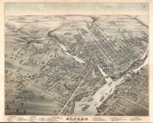
Bird's Eye View of the City of Bangor Penobscot County, Maine, 1875.
sold
- Digital Map Information
- Suitable for large format printing
- File Size: 1019.87 MB
- File Type: ZIP / TIFF
- ICC color profile embedded
- Delivered instantly via download link
An exceptional 1875 chromolithograph bird's-eye view map of Bangor, Maine, by Augustus Koch and J. J. Stoner. The view illustrates Bangor at its height as one of the world's foremost lumber towns. (more details)
Rare view of one of Vermont's most beautiful and historic cities.
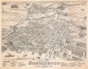
Birds Eye View of Burlington and Winooski VT.
sold
- Digital Map Information
- Suitable for large format printing
- File Size: 59.96 MB
- File Type: ZIP / TIFF
- ICC color profile embedded
- Delivered instantly via download link
A beautiful 1877 bird's-eye view and map of Burlington and Winooski, Vermont by Joseph J. Stoner and E. Meilbek. The view looks on Burlington from a point to the southwest high above Lake Champlain, with Main Street at the center of the map eastward proceeding from the lake.. In the distance, to the northeast, the neighboring town of Winooski is well drawn across the Winooski River. Even farther, the forested Green Mountains are prominent. The view is based on artwork by E. Meilbek, of whom almost nothing is known. (more details)