
Smith, Elder, and Company (sold)

Smith, Elder, and Company (1816 - 1917) was a publishing firm based in London that was founded by two Scottish men: George Smith (1789 - 1846) and Alexander Elder (1790 - 1876). Founded in 1816, Smith, Elder and Company’s first three years in business were spent selling pens, paper, pencils, ink, account books, and other similar items, along with both new and used books, journals, and musical scores. A major portion of their clientele was officers from the East India Company, which significantly helped build the firm’s financial strength. Three years later the firm entered the publishing world when they released Sermons and Expositions on Interesting Portions of Scripture by John Morison. A third partner, Patrick Stewart, joined the company in 1824, and the company moved to Cornhill. The firm continued publishing small works, particularly editions meant to be bought as gifts, until 1843 when George Smith’s son, George Murray Smith (March 18, 1824 – April 6, 1901), who had joined the firm in 1838 and worked his way up through the ranks to become head of the small publishing arm of the business, agreed to publish the first volume of Modern Painters by John Ruskin, which launched a very lucrative thirty-year relationship between the publishing house and Ruskin. Other major successes followed, but very few would compare to George Murray Smith’s decision to publish Charlotte Brontë’s Jane Eyre, which created a deep, personal friendship between the publisher and author. Smith also managed to entice many renowned authors to publish with the firm, including Robert Browning, William Makepeace Thackeray, and Anthony Trollope. Smith, Elder, and Company began publishing their well-received literary journal The Cornhill in 1859, which published serialized novels by both Trollope and Thackeray in its first year. The first issue reportedly sold 120,000 copies. The firm continued to see success in the late 19th century. But, after Reginald Smith, George Murray Smith’s son-in-law, died on December 26, 1916, no one was left to continue running the company. All book rights and remaining stock were bought by John Murray in May 1917.
One of the earliest maps of the colony of New Zealand.
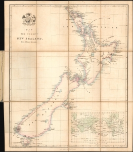
Map of the Colony of New Zealand from Official Documents.
sold
- Digital Map Information
- Suitable for large format printing
- File Size: 8.8 MB
- File Type: ZIP / TIFF
- ICC color profile embedded
- Delivered instantly via download link
This is a rare c. 1841 Smith, Elder and Company map of New Zealand issued soon after it became a British colony. Reduced from John Arrowsmith's May 2, 1841 map of the same title, this is among the earliest maps of the New Zealand colony. This Smith, Elder and Company edition was published by the New Zealand Company, as part of their efforts to promote settlement in the colony. Despite being derived from the first issue of Arrowsmith's map, the present work predates most examples of the Arrowsmith, which had a very long publication history. (more details)
One of the earliest maps of the colony of New Zealand.
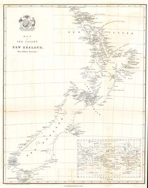
Map of the Colony of New Zealand from Official Documents.
sold
- Digital Map Information
- Suitable for large format printing
- DPI: 600
- File Size: 6.83 MB
- File Type: ZIP / TIFF
- ICC color profile embedded
- Delivered instantly via download link
This is a rare c. 1841 Smith, Elder and Company map of New Zealand issued soon after it became a British colony. One of the earliest maps of the New Zealand colony, the map depicts both the North and South Islands and labels several early settlements, including Auckland, New Plymouth, and Wellington. Although undated, the presence of Wellington solidifies that this map must have been produced after November 1840, when the directors of the New Zealand Company (whose crest adorns the title cartouche) decreed that the newly settled town at Lambton Harbor would henceforth be named after the Duke of Wellington, reflecting his support of the company’s principles of colonization. An inset map of the world in the lower right illustrates New Zealand's global location. (more details)