
Tanaka Taemon (sold)

Tanaka Taemon (田中太右衛門; fl. c. 1777 - 1940) was the hereditary name of the family that led Sōeidō (宋栄堂), one of Osaka's most enduring publishing houses, operating from the mid-Edo period until the Second World War. Several branches of the Tanaka family operated in the publishing business in the late Edo period, including the firm founded in 1804 by Tanaka Sōkichi (田中宗吉), a former clerk at the prominent Osaka bookseller Akitaya Ichibei (秋田屋市兵衛). Operating throughout the late Edo period under the merchant trade name Akitaya Taemon (秋田屋太右衛門) alongside the studio name Sōeidō, the house grew into a major regional publisher. It produced and distributed Buddhist texts, classical Chinese (kanbun) commentaries, reference works, and illustrated woodblock books — including collaborations with noted Osaka ukiyo-e artist Matsukawa Hanzan — while frequently co-publishing multi-volume titles with leading bookshops in Edo and Kyoto. Following the Meiji Restoration, as traditional merchant guild names (yagō) gave way to family surnames, the firm transitioned from Akitaya Taemon to Tanaka Taemon / Tanaka Sōeidō, operating Minami Ward in Osaka. Successfully adapting from traditional woodblock printing to modern movable type, the company capitalized on Meiji educational reforms and rising literacy by publishing pocket dictionaries, self-study manuals, school textbooks, and popular classical Chinese anthologies edited by scholars such as Kondō Gensui. It also remained an active publisher and distributor of commercial atlases and regional maps, frequently partnering with neighboring compiler and printer Ōtsuka Usaburō on travel guides and cartographic works.
Japanese Seizure of Taiwan.
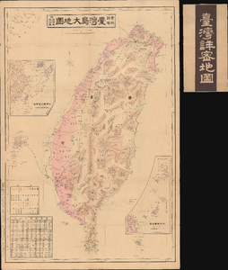
實測詳密 台灣島大地圖 附-澎湖島 琉球島 / [Map of Taiwan Island Measured in Detail, with the Penghu and Ryukyu Islands].
sold
- Digital Map Information
- Suitable for large format printing
- Full resolution TIFF file
- ICC color profile embedded
- Delivered instantly via download link
This is an 1895 Ōtsuka Usaburō map of Taiwan, the Penghu Islands (also known as the Pescadores), and the Ryukyu Islands. It was prepared and published during Japan's conquest of Taiwan and includes a range of administratively useful information. The map helped to bring information about Japan's new colonial conquest and soon-to-be 'model colony' to a home audience. (more details)