
Frères, Thierry (sold)

Thierry Frères (fl. 1834 - c. 1850) was a French lithographic printing and publishing firm based at 1 Cité Bergère, Paris, active during the middle decades of the 19th century. The firm succeeded the Paris establishment of Godefroy Engelmann (1788 - 1839) around 1834-35 and produced maps, scientific illustrations, topographical views, and portraits. Its cartographic work included the lithographic printing of Agustín Codazzi's (1793 - 1859) Atlas físico y político de la República de Venezuela, dated Caracas, 1840, but printed in Paris. The atlas combined historical, physical, and administrative mapping, including maps of Venezuela's provinces, comparative mountain and river diagrams, and representations of the campaigns of independence; most of its maps bear the Thierry Frères imprint. The firm's name also appears among the lithographic contributors to the atlas accompanying the historical account of the Russian circumnavigation aboard the corvette Séniavine, published in Paris in 1835-36. Alongside these geographical and scientific commissions, Thierry Frères printed architectural and landscape subjects, including illustrations for Voyages pittoresques et romantiques dans l'ancienne France, and numerous portraits. Surviving impressions document work for different publishers rather than a business confined to issuing its own publications. The house continued producing topographical lithographs around 1850, including plates for Souvenirs des Pyrénées.
Long-running Franco-Brazilian Territorial Dispute.
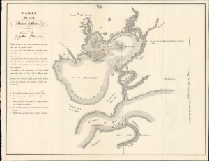
Carte des lacs Macari et Mapa levée à vue. dans la guyane francaise.
sold
- Digital Map Information
- Suitable for large format printing
- Full resolution TIFF file
- ICC color profile embedded
- Delivered instantly via download link
This is a rare c. 1837 map of a portion of Amapá state in northern Brazil, printed by Thierry Frères in Paris. At the time, France and Brazil were locked in a bitter territorial dispute over this sparsely inhabited and heavily forested area. The previous year, France took advantage of a separatist uprising in the Brazilian province of Grão-Pará, which included the area seen here, to stake a claim to the territory and extend the southern border of French Guiana. The resulting crisis nearly led to war, and even after the two sides agreed to demilitarize the area in 1841, the dispute was not resolved until an international arbitration commission ruled in Brazil's favor in 1900. (more details)
One of the earliest views of Singapore!
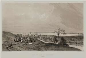
Rade et Ville de Sincapour. (Malaisie).
sold
- Digital Map Information
- Suitable for large format printing
- Full resolution TIFF file
- ICC color profile embedded
- Delivered instantly via download link
One of the earliest obtainable views of Singapore, this is Eugène Cicéri's 1846 view of Singapore drawn from original sketches and maps compiled during Dumont d'Urville's (1790 - 1842) circumnavigation of the globe. The source sketches were created when d'Urville's ships, Astrolabe and Zellee, were at Singapore between June 27 and July 2, 1839. (more details)
Singapore's Chinatown.
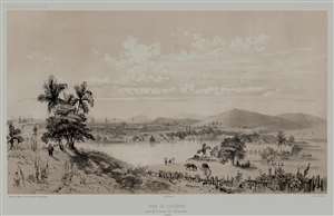
Rade de Sincapour Prise de la maison du Gouverneur. (Malaisie).
sold
- Digital Map Information
- Suitable for large format printing
- Full resolution TIFF file
- ICC color profile embedded
- Delivered instantly via download link
One of the earliest obtainable views of Singapore, this is Eugène Cicéri's 1846 view of Singapore drawn from original sketches and maps compiled during Jules Sébastien César Dumont d'Urville's (1790 - 1842) circumnavigation of the globe. The source sketches were created when d'Urville's ships, Astrolabe and Zélée, were at Singapore between June 27 and July 2, 1839. (more details)