
Tubau y Albert, Ignacio (sold)

Ignacio Tubau y Albert (fl. c. 1850 - 1872) was a Spanish engraver. Born in Barcelona, he was a follower of the Adacemia de San Fernando and was an engraver for the Direction de Hidrografia.
Includes the city of Iloilo, the third most active port in the Philippines.
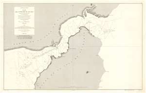
Archipiélago Filipino. Plano del Estrecho de Ilo - Ilo.
sold
- Digital Map Information
- Suitable for large format printing
- File Size: 53.29 MB
- File Type: ZIP / TIFF
- ICC color profile embedded
- Delivered instantly via download link
This is an 1875 Direccion de Hidrografia and D. Claudio Montero nautical chart or maritime map of the Iloilo Strait in the Philippines. The Iloilo Strait separates Panay Island from Guimaras Island and connects the Panay Gulf with the Guimaras Strait. Depth soundings are indicated throughout, as are banks and shoals. Points along the coast are labeled, as is the port city of Iloilo, which is today the third busiest port in the Philippines with regard to number of ships. A manuscript anchor in drawn near Iloilo, indicating the presence of a safe harbor. (more details)