
Verseyl Visscher, Elizabeth (sold)

Elizabeth Verseyl Visscher (16?? - 1726) was a Dutch atlas publisher. It is not known when she was born, and nothing is known of her education. On December 10, 1680, she married mapmaker Nicolaes Visscher II (1649 – May 31, 1702). When Nicolaes died, Elizabeth ran the business, both continuing to publish Nicolaes' maps and adding to the company's oeuvre until 1726, at which point the stock of copperplates was sold to Peter Schenk. (It is not known whether the sale preceded her death, or was posthumous.)
We are not aware of any instance of Verseyl Visscher's name appearing on a map; rather she is identified as 'Widow of Nicolaes Visscher.'
We are not aware of any instance of Verseyl Visscher's name appearing on a map; rather she is identified as 'Widow of Nicolaes Visscher.'
State of the Art of Mapping Peter's Russia.
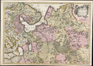
Nouvelle Carte Geographique du Grand Royaume de Moscovie Representant la Partie Septentrionale etc. Par Nicolas Visscher a Amsteldam avec Privilege des Etats Generaux.
sold
- Digital Map Information
- Suitable for large format printing
- Full resolution TIFF file
- ICC color profile embedded
- Delivered instantly via download link
This is a striking old color example of Elizabeth Verseyl Visscher's scarce c. 1709 map of Russia. Though bearing the imprint of Nicholas Visscher II (1649 - 1702), it was updated and issued by his widow, Verseyl Visscher, who managed the firm until her 1726 death. Under her guidance and in collaboration with Peter the Great's geographers, this, the most up-to-date map of the Russian Empire, was added to the Visscher oeuvre. (more details)
Early Woman Map Publisher.
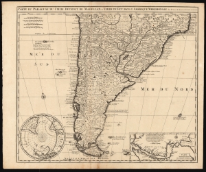
Carte du Paraguay, du Chili, Détroit de Magellan, et Terre de Feu dans l'Amerique Meridionale.
sold
- Digital Map Information
- Suitable for large format printing
- DPI: 600
- File Size: 64.4 MB
- File Type: ZIP / TIFF
- ICC color profile embedded
- Delivered instantly via download link
This is Elizabeth Verseyl Visscher's scarce, c. 1710 map of southern South America, based on the 1703 map by Guillaume De l'Isle. It is notable in particular for being the first published map to include a new, 1702 charting of the Strait of Magellan, which had been suppressed by the Chancellor of France, the Comte de Pontchartrain. (more details)