
Wightman, Henry Morse (sold)

Henry Morse Wightman (January 5, 1840 - April 3, 1885) was an American civil engineer. Born in Cambridge, Massachusetts, Wightman graduated from the English high school in 1857. He joined the office of the city engineer as a 'rodman' soon after graduation and spent the rest of his life working in that office. He worked on the project to raise the waters of Lake Cochituate, the rebuilding of the Dover Street bridge, oversaw the construction of the Public Garden, and was the engineer for the Back Bay Commission. As such he completed surveys and plans for the filling and laying out of the whole Back Bay territory and surveyed the entire Stony Brook watershed. After the Back Bay project was completed, Wightman returned to the office of the city engineer and soon became the resident engineer in charge of the work at the Chestnut Hill Reservoir. In 1870, Wightman became the chief assistant to city engineer Nathaniel Henry Crafts and Joseph P. Davis. When Davis retired in 1880, the city council named Wightman city engineer, a position he held until his death of double pneumonia.
Expansion and urbanization.
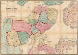
Plan of Boston Corrected under the direction of Charles W. Slack, Lewis Rice, Danl. J. Sweeney, Alderman, Com. Council, Committee on Printing, of 1867, by N. Henry Crafts, City Engineer.
sold
- Digital Map Information
- Suitable for large format printing
- Full resolution TIFF file
- ICC color profile embedded
- Delivered instantly via download link
An 1867 city map of Boston produced for the Boston City Engineer's Office. This map, updated regularly and based upon official engineering records, represents the finest mapping of Boston between 1860 and 1870 - Boston's most vibrant period of expansion, landfill development, urbanization, and modernization. (more details)