
Willis, Christopher James (sold)

Christopher James Willis (1872 - July 29, 1928) was a native Hawaiian surveyor and engineer. Born in Hawaii, Willis was the adopted son of the Right Reverend Alfred Willis, Lord Bishop of Honolulu of the Anglican church in Hawaii. He spent over forty years working for the Hawaiian Territorial Survey, followed by the Hawaiian Territorial Tax Office, and finally he served as the Assistant Engineer in the Honolulu Department of Public Works. As a teen Willis was one of Oahu's best baseball and football players and a track and field star. He died of injuries sustained after falling from a tree in his yard on Oahu. He married Emma Mossman on August 10, 1899, with whom he had one son.
Most sophisticated 19th century map of Molokai.
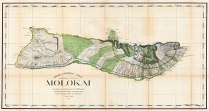
Hawaiian Government Survey. Molokai.
sold
- Digital Map Information
- Suitable for large format printing
- File Size: 154.9 MB
- File Type: ZIP / TIFF
- ICC color profile embedded
- Delivered instantly via download link
This 1897 Christopher Willis map of Molokai is the most sophisticated 19th century mapping of the island. Surveyors from the Hawaiian Government Survey mapped the length and breadth of Molokai and, per Moffat and Fitzpatrick, the map 'represents the final stage in the process of understanding and correctly illustrating the shape of this elongated island between O'ahu and Maui'. (more details)