
Yamanaka Yoshisaburō (sold) (山中善三朗)

Yamanaka Yoshisaburō (山中善三朗; fl. c. 1888 – 1890) was an engraver and printer based in Honjo Ward, Tokyo (a new-defunct administrative district on the east bank of the Sumida River).
AKA: 山中善三朗
Reorganizing Japan's imperial capital.
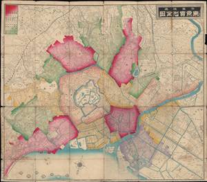
市區改正東亰實測全圖 / [Complete Survey Map of Tokyo with Revised Wards].
sold
- Digital Map Information
- Suitable for large format printing
- Full resolution TIFF file
- ICC color profile embedded
- Delivered instantly via download link
This is an 1889 folding survey map of Tokyo, Japan by Ishijima Yae and Yamanaka Yoshisaburō. Its primary purpose is to highlight recent administrative changes in Tokyo, namely the creation of Tokyo Municipality (東京市), composed of 15 wards (區), within the larger Tokyo Prefecture (東京府). This map likely would have been used in a government office for reference purposes; the outside cover appears to include a list of names which might indicate its provenance, but the surname characters (at top) are unintelligible. (more details)