
Yamazaki Hatsutaro (sold) (山崎初太郎)

Yamazaki Hatsutaro (山崎初太郎; fl. c. 1898 - 1946) was a Japanese travel and cargo agent based in Kobe, Japan. His, firm, the 'Travel Case Office' focused on shipping between Kobe and North American ports, including Hawaii. He was active from at least 1898 to about 1946, when he declared bankruptcy. He worked with various shipping companies, including Nippon Yusen Kabushiki Kaisha, Osaka Shosen Kaisha, Toyo Kisen Kaisha, and Taiheiyo Yusen Kaisha. Hatsutaro is credited with only one map, a large-scale broadsheet guide for Japanese immigrants to America.
AKA: 山崎初太郎
Japanese immigration guide to America!
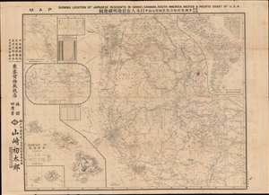
Map Showing Location of Japanese Residents in Hawaii, Canada, South America, Mexico and the Pacific Coast of USA. / 和英両文米国, 布哇, 加奈陀, 墨西哥及南米日本人在住地明細地圖
sold
- Digital Map Information
- Suitable for large format printing
- Full resolution TIFF file
- ICC color profile embedded
- Delivered instantly via download link
This is a fascinating large scale 1917 Yamazaki Hatsutaro map of the western United States and Hawaii designed act as a guide for Japanese immigrants to the America. The map is centered on California - then the hub of Japanese immigration and cultural life in North America - and extends eastward roughly to Nebraska and Texas. A large inset in the lower left details the Hawaiian Islands, also a center of Japanese immigration. Smaller insets detail global shipping routes, South America, and the Pacific northwest including British Columbia and Alaska. Smaller tables offer statistics on Japanese population density broken down by state, with California having the highest concentration of émigrés. The verso features a comprehensive bi-lingual index and promotional material for Japanese-friendly hotels, steamers, newspapers, and other services. (more details)