
Ackerman, James (sold)

James Ackerman (1816 - March 24, 1864) was an American painter, engraver, and lithographer active in New York City in the mid-19th century. Ackerman was born in New York. He rose to prominence as a lithographer and painter - best known for his floral prints, some of which were favorably lauded by none other than Edgar Allen Poe. He was also associated with the banner and sign painting firm of Ackerman and Miller until his death. His offices were at 120 Fulton Street and later at 379 Broadway. He frequently printed for the U.S. government, including work for the U.S. Coast Survey and the General Land Office. I have found few references to what happened to Ackerman later in life, but his residence at death is identified as the Bloomingdale Insane Asylum. Ackerman is interred in Brooklyn at Greenwood Cemetery.
'First Colton map showing the gold fields.' - Streeter
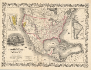
Map of the United States The British Provinces Mexico and c. Showing the Routes of the U.S. Mail Steam Packets to California and a Plan of the Gold Region.
sold
- Digital Map Information
- Suitable for large format printing
- DPI: 600
- File Size: 72.59 MB
- File Type: ZIP / TIFF
- ICC color profile embedded
- Delivered instantly via download link
This is J. H. Colton and J. M. Atwood's 1849 map of the United States, issued to illustrate routes to the newly discovered gold fields in California. Issued immediately in the wake of the gold discovery at Sutter's Mill, this is the first Colton map to illustrate the California Gold Fields. It also Texas in its largest configuration, immediately after the Treaty of Guadalupe Hidalgo. (more details)
Surveying the Great Salt Lake.
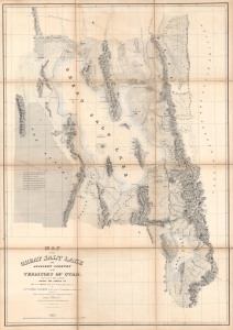
Map of the Great Salt Lake and Adjacent Country in the Territory of Utah.
sold
- Digital Map Information
- Suitable for large format printing
- Full resolution TIFF file
- ICC color profile embedded
- Delivered instantly via download link
An iconic map of the American West, this is a beautiful presentation edition of Howard Stansbury's crucial mapping of the Great Salt Lake, the earliest accurate survey of the region. Originally published in 1852 as part of the Stansbury Report presented to the U.S. Congress that year, the present example is mounted on linen and folds into a case, as it was intended for a member of Congress. This is, hands down, the finest example we've seen of this map, and if you're considering it for your collection, this is the one you want. (more details)
Early surveying expedition to the American West.
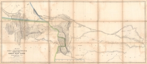
Map of a Reconnaissance between Fort Leavenworth and the Missouri River, and the Great Salt Lake in the Territory of Utah, made in 1849 and 1850…
sold
- Digital Map Information
- Suitable for large format printing
- Full resolution TIFF file
- ICC color profile embedded
- Delivered instantly via download link
A monumental map, matching the landscape it depicts, this is Howard Stansbury's seminal map of the lands between Fort Leavenworth, Kansas, and Pilot Peak (now Nevada), west of the Great Salt Lake. Originally published in 1852 as part of the Stansbury Report presented to the U.S. Congress that year, the present example is mounted on linen and folds into a case, as it was intended for a member of Congress. This is hand-down the finest example we've seen of this map, and if you are considering it for your collection, this is the one you want. (more details)